Predictions for Grazing Occultation of ZC 648, 2016 Nov 15
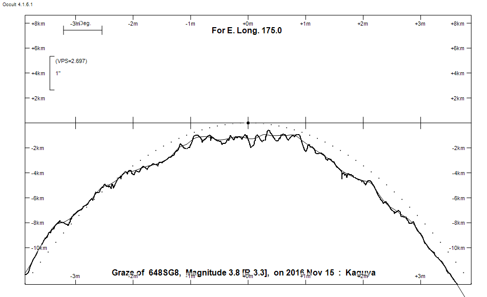
Graze profile
Grazing Occultation of     648SG8      Magnitude 3.8 [Red = 3.3]  s
   R648 = Hyadum II = delta 1 Tauri
Date: 2016 Nov 15 11h 49m,  to  2016 Nov 15 12h  8m

Nominal site altitude 100m

E. Longit.   Latitude       U.T.    Sun  Moon   TanZ   PA    AA      CA
   o  '  "    o  '   "    h  m  s   Alt Alt Az          o     o      o
 167  0  0  -40 31 54.4  11 48 30       27  29  1.97 343.9 353.29  23.78N
 167 30  0  -40 17 42.3  11 49  9       27  28  1.93 343.9 353.30  23.77N
 168  0  0  -40  3 31.1  11 49 49       28  28  1.90 343.9 353.31  23.76N
 168 30  0  -39 49 21.0  11 50 30       28  27  1.86 343.9 353.32  23.75N
 169  0  0  -39 35 12.5  11 51 12       29  26  1.83 344.0 353.33  23.74N
 169 30  0  -39 21  5.7  11 51 54       29  26  1.79 344.0 353.34  23.73N
 170  0  0  -39  7  0.9  11 52 38       30  25  1.76 344.0 353.36  23.71N
 170 30  0  -38 52 58.5  11 53 22       30  25  1.73 344.0 353.38  23.69N
 171  0  0  -38 38 58.7  11 54  7       30  24  1.70 344.0 353.40  23.67N
 171 30  0  -38 25  1.8  11 54 53       31  23  1.67 344.1 353.43  23.65N
 172  0  0  -38 11  8.2  11 55 39       31  23  1.64 344.1 353.45  23.62N
 172 30  0  -37 57 18.2  11 56 27       32  22  1.62 344.1 353.48  23.59N
 173  0  0  -37 43 32.1  11 57 15       32  21  1.59 344.1 353.52  23.56N
 173 30  0  -37 29 50.2  11 58  4       33  20  1.57 344.2 353.55  23.53N
 174  0  0  -37 16 13.0  11 58 53       33  20  1.54 344.2 353.59  23.49N
 174 30  0  -37  2 40.8  11 59 44       33  19  1.52 344.3 353.63  23.45N
 175  0  0  -36 49 13.9  12  0 35       34  18  1.50 344.3 353.67  23.41N
 175 30  0  -36 35 52.8  12  1 27       34  17  1.47 344.3 353.72  23.37N
 176  0  0  -36 22 37.7  12  2 20       35  17  1.45 344.4 353.77  23.32N
 176 30  0  -36  9 29.2  12  3 13       35  16  1.43 344.4 353.82  23.27N
 177  0  0  -35 56 27.4  12  4  7       35  15  1.41 344.5 353.87  23.21N
 177 30  0  -35 43 32.9  12  5  2       36  14  1.40 344.6 353.93  23.16N
 178  0  0  -35 30 46.0  12  5 58       36  14  1.38 344.6 353.99  23.10N
 178 30  0  -35 18  7.1  12  6 54       36  13  1.36 344.7 354.06  23.03N
 179  0  0  -35  5 36.5  12  7 51       37  12  1.34 344.8 354.12  22.97N

Path coordinates are referred to WGS84 (as used by GPS), with the
nominal site altitude being referenced to Mean Sea Level. The path
is adjusted for the effects of refraction at low moon altitudes.

Projected diameter of star  8 meters  [CHARM/CADARS, 13 measures]

648 is variable:
       648 = NSV 1582, 3.72 to 3.77, V

648 is quadruple:
  Aa,Ab 3.8 12.9      350.0 (CHR 262) Graze path of Ab approximately 0.0 km south, and 0.0 secs later compared to Aa
  - refer to graze profile for exact distances
  Aa,Ab 3.9 9.5 0.70"   8.9 (CHR 262) Graze path of Ab approximately 1.9 km south, and 0.7 secs later compared to Aa
  - refer to graze profile for exact distances
  AB 3.8 13.2 112" 335.6 (BUP  55) Graze path of B approximately 339.0 km south, and 37.7 secs earlier compared to A
  - refer to graze profile for exact distances

    C A S S I N I   R E G I O N   G R A Z E
                Librations  Long +2.72   Lat +5.78
                            P +353.75     D -5.79
      Illumination of moon  98%-
        Elongation of Moon  166
    Vertical Profile Scale  approx. 2.84 km/arcsec at mean distance of moon
   Horizontal Scale Factor  1.52 deg/min


At longitude 173.00:
Limiting Magnitudes for various telescope apertures (in cm)
      CA\Tdia   5    10    15    20    25    30    35
    19.6      4.2   5.6   6.4   6.8   7.1   7.3   7.5
    21.6      4.2   5.7   6.4   6.8   7.1   7.3   7.5
    23.6      4.2   5.7   6.4   6.8   7.1   7.3   7.5
    25.6      4.3   5.7   6.4   6.9   7.1   7.3   7.5
    27.6      4.3   5.7   6.4   6.9   7.2   7.4   7.5

------------------------------------------------------------------------------
AAVSO Variable star entry

       Variable identifier           Type        Max    Min  Ph  Epoch         Period
       NSV 1582                                  3.72   3.77 V
------------------------------------------------------------------------------
Results of Observer Scan                                    UT
Site                              Long.   Lat.   Dist.    h  m  s
Auckland                          174.8  -36.9     1km   12  0 14.5
MidNZ                             173.0  -41.0   311km   11 57 14.7
Lunar Limb Profile