Predictions for Grazing Occultation of SAO118541, 2016 Aug 5
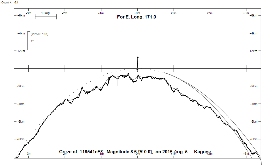
Graze profile
Grazing Occultation of  118541cF8      Magnitude 8.6 [Red = 0.0]
Date: 2016 Aug 05  6h 29m,  to  2016 Aug 05  6h 35m

Nominal site altitude 100m

E. Longit.   Latitude       U.T.    Sun  Moon   TanZ   PA    AA      CA
   o  '  "    o  '   "    h  m  s   Alt Alt Az          o     o      o
 167  0  0  -43 20 30.8   6 28 50   -6  18 301  2.99  23.6 359.67   1.88N
 167 30  0  -43 29  5.3   6 29 11   -7  18 300  3.07  23.5 359.59   1.80N
 168  0  0  -43 37 33.0   6 29 31   -7  18 300  3.15  23.4 359.51   1.72N
 168 30  0  -43 45 54.1   6 29 51   -8  17 299  3.24  23.3 359.43   1.64N
 169  0  0  -43 54  8.1   6 30 10   -8  17 299  3.33  23.3 359.35   1.56N
 169 30  0  -44  2 15.4   6 30 28   -8  16 299  3.42  23.2 359.28   1.48N
 170  0  0  -44 10 16.1   6 30 46   -9  16 298  3.52  23.1 359.20   1.41N
 170 30  0  -44 18 10.3   6 31  4   -9  15 298  3.62  23.0 359.12   1.33N
 171  0  0  -44 25 57.9   6 31 21  -10  15 297  3.73  22.9 359.05   1.26N
 171 30  0  -44 33 38.6   6 31 38  -10  15 297  3.84  22.9 358.97   1.18N
 172  0  0  -44 41 13.3   6 31 54  -11  14 296  3.96  22.8 358.90   1.11N
 172 30  0  -44 48 41.8   6 32  9  -11  14 296  4.08  22.7 358.82   1.03N
 173  0  0  -44 56  4.0   6 32 24  -11  13 296  4.21  22.6 358.75   0.96N
 173 30  0  -45  3 20.0   6 32 39  -12  13 295  4.35  22.6 358.68   0.89N
 174  0  0  -45 10 29.9   6 32 53       13 295  4.50  22.5 358.60   0.81N
 174 30  0  -45 17 33.6   6 33  7       12 294  4.65  22.4 358.53   0.74N
 175  0  0  -45 24 31.4   6 33 20       12 294  4.82  22.4 358.46   0.67N
 175 30  0  -45 31 23.3   6 33 33       11 294  4.99  22.3 358.39   0.60N
 176  0  0  -45 38  9.2   6 33 45       11 293  5.18  22.2 358.32   0.53N
 176 30  0  -45 44 49.2   6 33 57       11 293  5.38  22.1 358.25   0.46N
 177  0  0  -45 51 23.5   6 34  8       10 292  5.60  22.1 358.18   0.39N
 177 30  0  -45 57 52.0   6 34 19       10 292  5.83  22.0 358.11   0.32N
 178  0  0  -46  4 14.8   6 34 30        9 292  6.08  21.9 358.04   0.25N
 178 30  0  -46 10 31.9   6 34 40        9 291  6.34  21.9 357.98   0.18N
 179  0  0  -46 16 43.5   6 34 50        9 291  6.64  21.8 357.91   0.12N

Path coordinates are referred to WGS84 (as used by GPS), with the
nominal site altitude being referenced to Mean Sea Level. The path
is adjusted for the effects of refraction at low moon altitudes.

118541 is double:
  Graze prediction is based on the mean position of AB 8.72 11.24 0.70"   4.0
 (HDS1550) Graze path of A approximately 0.1 km north, and 0.0 secs later compared to prediction
  Graze path of B approximately 1.3 km south, and 0.4 secs earlier compared to prediction
  - refer to graze profile for exact distances

  AB 8.72 11.24 0.70"   4.0 (HDS1550) Graze path of B approximately 1.4 km south, and 0.5 secs earlier compared to A
  - refer to graze profile for exact distances

                Librations  Long +3.94   Lat -0.28
                            P +358.72     D +0.46
      Illumination of moon  6%+
        Elongation of Moon  28
    Vertical Profile Scale  approx. 2.18 km/arcsec at mean distance of moon
   Horizontal Scale Factor  1.73 deg/min


At longitude 173.00:
Limiting Magnitudes for various telescope apertures (in cm)
      CA\Tdia   5    10    15    20    25    30    35
    -3.0      6.6   8.0   8.8   9.3   9.6   9.8  10.0
    -1.0      7.1   8.6   9.4   9.9  10.2  10.5  10.7
     1.0      7.2   8.6   9.4  10.0  10.3  10.6  10.8
     3.0      7.2   8.7   9.5  10.0  10.4  10.6  10.8
     5.0      7.2   8.7   9.5  10.0  10.4  10.7  10.9

------------------------------------------------------------------------------
Results of Observer Scan                                    UT
Site                              Long.   Lat.   Dist.    h  m  s
Chch graze                        172.6  -43.5   138km    6 32 13.3
Dunedin                           170.5  -45.9   164km    6 31  3.8
Lunar Limb Profile