Predictions for Grazing Occultation of ZC 155, 2016 Jul 25
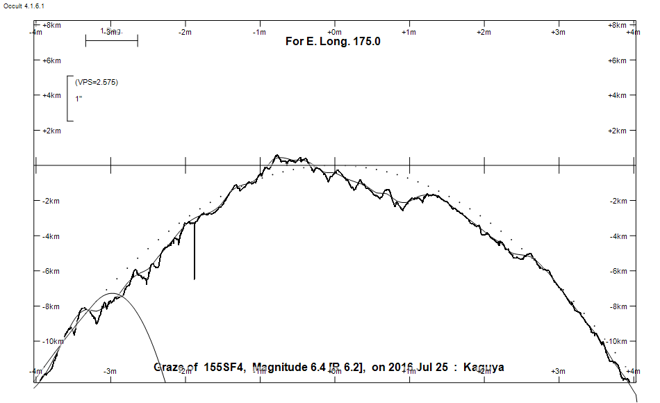
Graze profile
Grazing Occultation of     155SF4      Magnitude 6.4 [Red = 6.2]
   R155 = 77 Piscium
Date: 2016 Jul 25 17h 32m,  to  2016 Jul 25 17h 59m

Nominal site altitude 100m

E. Longit.   Latitude       U.T.    Sun  Moon   TanZ   PA    AA      CA
   o  '  "    o  '   "    h  m  s   Alt Alt Az          o     o      o
 167  0  0  -44  3 19.8  17 32 13       41   4  1.15 333.8 357.49   4.44N
 167 30  0  -43 47 19.0  17 33 13       41   3  1.14 333.8 357.46   4.47N
 168  0  0  -43 31 13.0  17 34 14       42   2  1.12 333.7 357.43   4.50N
 168 30  0  -43 15  1.9  17 35 15       42   1  1.11 333.7 357.41   4.52N
 169  0  0  -42 58 46.0  17 36 17       42 360  1.10 333.7 357.38   4.55N
 169 30  0  -42 42 25.8  17 37 20       42 359  1.09 333.7 357.36   4.57N
 170  0  0  -42 26  1.5  17 38 24       43 358  1.08 333.6 357.34   4.59N
 170 30  0  -42  9 33.5  17 39 28       43 357  1.07 333.6 357.32   4.61N
 171  0  0  -41 53  2.2  17 40 33       43 355  1.06 333.6 357.31   4.62N
 171 30  0  -41 36 27.9  17 41 38       43 354  1.06 333.6 357.30   4.63N
 172  0  0  -41 19 51.0  17 42 44       44 353  1.05 333.6 357.29   4.64N
 172 30  0  -41  3 12.0  17 43 51       44 352  1.04 333.6 357.28   4.65N
 173  0  0  -40 46 31.4  17 44 59       44 351  1.03 333.6 357.28   4.65N
 173 30  0  -40 29 49.5  17 46  6       44 350  1.03 333.6 357.28   4.65N
 174  0  0  -40 13  6.7  17 47 15       44 349  1.02 333.6 357.28   4.65N
 174 30  0  -39 56 23.6  17 48 24       45 348  1.02 333.6 357.28   4.65N
 175  0  0  -39 39 40.6  17 49 33       45 347  1.01 333.6 357.29   4.64N
 175 30  0  -39 22 58.1  17 50 43       45 345  1.01 333.6 357.30   4.63N
 176  0  0  -39  6 16.8  17 51 53       45 344  1.00 333.6 357.32   4.61N
 176 30  0  -38 49 37.3  17 53  3       45 343  1.00 333.6 357.34   4.59N
 177  0  0  -38 32 59.9  17 54 14       45 342  1.00 333.7 357.36   4.57N
 177 30  0  -38 16 25.1  17 55 25       45 341  1.00 333.7 357.39   4.55N
 178  0  0  -37 59 53.7  17 56 36       45 339  0.99 333.7 357.41   4.52N
 178 30  0  -37 43 25.9  17 57 48       45 338  0.99 333.7 357.45   4.48N
 179  0  0  -37 27  2.4  17 58 59       45 337  0.99 333.8 357.48   4.45N

Path coordinates are referred to WGS84 (as used by GPS), with the
nominal site altitude being referenced to Mean Sea Level. The path
is adjusted for the effects of refraction at low moon altitudes.

155 is multiple:
  AB 6.4 7.3 33"  83.0 (STF  90) Graze path of B approximately 29.7 km north, and 76.3 secs later compared to A
  - refer to graze profile for exact distances
  AD 6.4 14.6 42" 323.7 (STF  90) Graze path of D approximately 112.4 km south, and 17.8 secs earlier compared to A
  - refer to graze profile for exact distances
  AE 6.4 14.4 91" 352.0 (STF  90) Graze path of E approximately 233.0 km south, and 70.3 secs later compared to A
  - refer to graze profile for exact distances
  AC 6.4 13.1 157" 290.2 (STF  90) Graze path of C approximately 310.0 km south, and 265.3 secs earlier compared to A
  - refer to graze profile for exact distances

    C A S S I N I   R E G I O N   G R A Z E
                Librations  Long -1.44   Lat +3.03
                            P +357.20     D -2.70
      Illumination of moon  64%-
        Elongation of Moon  106
    Vertical Profile Scale  approx. 2.61 km/arcsec at mean distance of moon
   Horizontal Scale Factor  1.45 deg/min


At longitude 173.00:
Limiting Magnitudes for various telescope apertures (in cm)
      CA\Tdia   5    10    15    20    25    30    35
     0.7      2.9   4.3   5.1   5.6   5.9   6.1   6.2
     2.7      4.8   6.3   7.0   7.5   7.9   8.1   8.3
     4.7      5.0   6.5   7.2   7.7   8.1   8.3   8.5
     6.7      5.7   7.1   7.9   8.4   8.8   9.0   9.2
     8.7      5.7   7.1   7.9   8.4   8.8   9.0   9.2

------------------------------------------------------------------------------
Double star catalogue details
WDS entries

  RA  Dec Name          Y1   Y2     N  PA  PA   Sep   Sep  M1    M2
01058+0455STF  90AB    1782 2014  107  85  83  29.6  32.9  6.39  7.26 F3V  F5V  +014-121 +032-123 +04  175 NVD  010549.22+045431.2
01058+0455STF  90AC    1910 2011    6 286 290 152.2 157.0  6.39 13.15 F3V       +014-121 +007+000          N    010549.22+045431.2
01058+0455STF  90AD    1910 1995    3 313 322  31.8  39.4  6.39 14.6  F3V       +026-120                   N    010549.22+045431.2
01058+0455STF  90AE    1910 2000    4 352 352  77.2  88.5  6.39 14.39 F3V       +014-121 +012+006          N    010549.22+045431.2
01058+0455TOK 202Ba,Bb 2011 2011    2  41  39   0.3   0.3  7.25 12.   F6V       +036-127                   N    010551.30+045436.9

------------------------------------------------
Interferometric catalogue entries

010549.22+045431.2  ADS   903                 STF  90AB                 HD   6479    HIP   5141         01058+0455 N
    Date       PA              Sep                  M1             M2
  1991.25        .      .   G   .         .         6.35    .       .      .       511 222   0.3   1  HIP1997g Hh
  1991.25      83.4     .     33.029      .         6.35    .      7.26    .       550       0.3   1  HIP1997b Hh
  1991.64      83.4     .     33.04       .         6.389  0.010   7.257  0.011    530 100   1.4   1  TYC2002  Ht
  1991.64        .      .       .         .         6.779  0.015   7.772  0.016    430  90   1.4   1  TYC2002  Ht
  2003.845     83.0     .     32.84       .          .      .       .      .       550       0.7   1  WSI2004b Su

010551.30+045436.9  ADS   903                 TOK 202Ba,Bb              HD   6480    HIP   5144         01058+0455 N
    Date       PA              Sep                  M1             M2
  2011.8433    41.0     .      0.251      .          .      .      4.46    .      1587  15   8.1   1  Tok2012a A
  2011.8433    38.6     .      0.254      .          .      .      3.96    .      2272  35   8.1   1  Tok2012a A


------------------------------------------------------------------------------
Results of Observer Scan                                    UT
Site                              Long.   Lat.   Dist.    h  m  s
Auckland                          174.8  -36.9   262km   17 49  5.1
Chch graze                        172.6  -43.5   225km   17 44  9.6
MidNZ                             173.0  -41.0    20km   17 44 58.5
Lunar Limb Profile