Predictions for Grazing Occultation of SAO109622, 2016 May 4
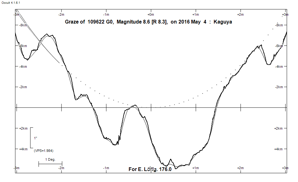
Graze profile
Grazing Occultation of  109622 G0      Magnitude 8.6 [Red = 8.3]
Date: 2016 May 04 18h  0m,  to  2016 May 04 18h  3m

Nominal site altitude 100m

E. Longit.   Latitude       U.T.    Sun  Moon   TanZ   PA    AA      CA
   o  '  "    o  '   "    h  m  s   Alt Alt Az          o     o      o
 167  0  0  -41 26 37.8  17 59 50        8  77  7.56 159.2 183.07   5.08S
 167 30  0  -41 22 41.8  17 59 54        8  77  7.18 159.1 183.01   5.02S
 168  0  0  -41 18 40.8  17 59 59        8  77  6.83 159.1 182.95   4.96S
 168 30  0  -41 14 34.7  18  0  4        9  76  6.52 159.0 182.89   4.90S
 169  0  0  -41 10 23.5  18  0  9        9  76  6.23 159.0 182.83   4.84S
 169 30  0  -41  6  7.2  18  0 14       10  75  5.96 158.9 182.76   4.77S
 170  0  0  -41  1 45.8  18  0 20       10  75  5.72 158.8 182.70   4.71S
 170 30  0  -40 57 19.1  18  0 26       10  75  5.49 158.8 182.64   4.65S
 171  0  0  -40 52 47.3  18  0 33       11  74  5.28 158.7 182.57   4.58S
 171 30  0  -40 48 10.1  18  0 40       11  74  5.08 158.6 182.51   4.52S
 172  0  0  -40 43 27.6  18  0 47       12  74  4.90 158.6 182.44   4.45S
 172 30  0  -40 38 39.7  18  0 54       12  73  4.72 158.5 182.38   4.39S
 173  0  0  -40 33 46.4  18  1  2       12  73  4.56 158.4 182.31   4.32S
 173 30  0  -40 28 47.7  18  1 10       13  73  4.41 158.4 182.25   4.26S
 174  0  0  -40 23 43.5  18  1 19       13  72  4.27 158.3 182.18   4.19S
 174 30  0  -40 18 33.7  18  1 28       14  72  4.13 158.2 182.11   4.12S
 175  0  0  -40 13 18.3  18  1 37       14  72  4.00 158.2 182.05   4.05S
 175 30  0  -40  7 57.2  18  1 47       14  71  3.88 158.1 181.98   3.99S
 176  0  0  -40  2 30.7  18  1 57       15  71  3.77 158.0 181.91   3.92S
 176 30  0  -39 56 58.2  18  2  7  -12  15  71  3.66 158.0 181.84   3.85S
 177  0  0  -39 51 19.8  18  2 18  -11  16  70  3.55 157.9 181.77   3.78S
 177 30  0  -39 45 35.6  18  2 29  -11  16  70  3.45 157.8 181.70   3.71S
 178  0  0  -39 39 45.5  18  2 41  -11  17  69  3.36 157.8 181.63   3.64S
 178 30  0  -39 33 49.2  18  2 53  -10  17  69  3.27 157.7 181.56   3.57S
 179  0  0  -39 27 47.2  18  3  6  -10  17  69  3.18 157.6 181.49   3.49S

Path coordinates are referred to WGS84 (as used by GPS), with the
nominal site altitude being referenced to Mean Sea Level. The path
is adjusted for the effects of refraction at low moon altitudes.


                Librations  Long -2.05   Lat +2.52
                            P +182.22     D +2.86
      Illumination of moon  6%-
        Elongation of Moon  28
    Vertical Profile Scale  approx. 2.05 km/arcsec at mean distance of moon
   Horizontal Scale Factor  1.95 deg/min


At longitude 173.00:
Limiting Magnitudes for various telescope apertures (in cm)
      CA\Tdia   5    10    15    20    25    30    35
     0.3      7.3   8.7   9.6  10.1  10.5  10.7  11.0
     2.3      7.3   8.8   9.6  10.1  10.5  10.8  11.0
     4.3      7.4   8.8   9.6  10.2  10.6  10.8  11.1
     6.3      7.4   8.9   9.7  10.2  10.6  10.9  11.1
     8.3      7.4   8.9   9.7  10.2  10.6  10.9  11.1

------------------------------------------------------------------------------
Results of Observer Scan                                    UT
Site                              Long.   Lat.   Dist.    h  m  s
MidNZ                             173.0  -41.0    47km   18  1  2.2
Wellington                        174.8  -41.3   113km   18  1 33.5
Lunar Limb Profile