Predictions for Grazing Occultation of ZC1413, 2016 Apr 16
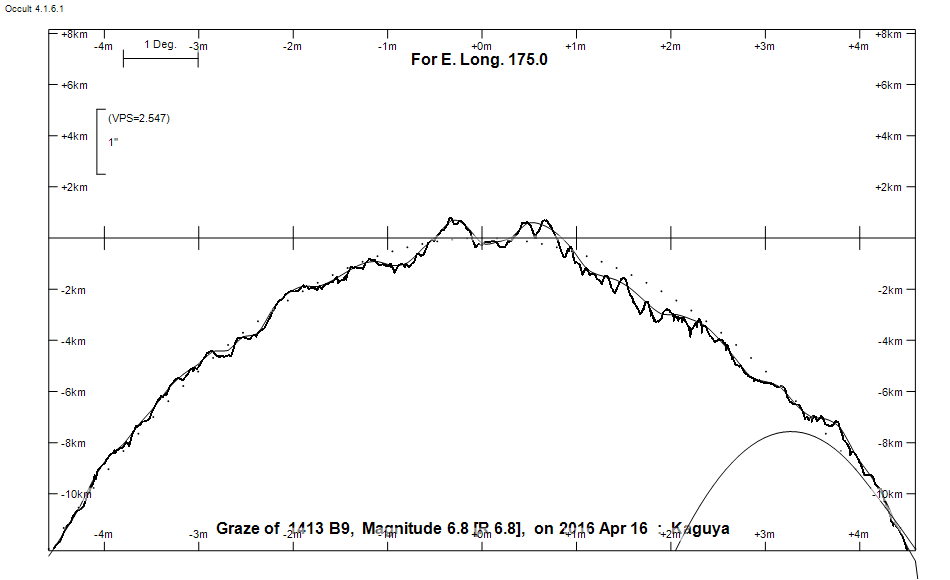
Graze profile
Grazing Occultation of    1413 B9      Magnitude 6.8 [Red = 6.8]
Date: 2016 Apr 16  8h 10m,  to  2016 Apr 16  8h 40m

Nominal site altitude 100m

E. Longit.   Latitude       U.T.    Sun  Moon   TanZ   PA    AA      CA
   o  '  "    o  '   "    h  m  s   Alt Alt Az          o     o      o
 167  0  0  -33 12 57.9   8 10 29       43  13  1.05  21.8   1.67   3.94N
 167 30  0  -33 26 42.9   8 11 48       43  12  1.06  21.9   1.78   4.05N
 168  0  0  -33 40 39.7   8 13  7       43  10  1.06  22.0   1.88   4.15N
 168 30  0  -33 54 47.9   8 14 25       43   9  1.06  22.1   1.97   4.24N
 169  0  0  -34  9  6.9   8 15 44       43   8  1.07  22.2   2.06   4.33N
 169 30  0  -34 23 36.2   8 17  2       43   7  1.07  22.3   2.15   4.42N
 170  0  0  -34 38 15.2   8 18 19       43   6  1.08  22.4   2.23   4.50N
 170 30  0  -34 53  3.4   8 19 37       43   5  1.09  22.4   2.30   4.57N
 171  0  0  -35  8  0.3   8 20 53       42   4  1.10  22.5   2.37   4.64N
 171 30  0  -35 23  5.1   8 22 10       42   3  1.10  22.6   2.44   4.71N
 172  0  0  -35 38 17.5   8 23 26       42   2  1.11  22.6   2.51   4.78N
 172 30  0  -35 53 36.7   8 24 41       42   1  1.12  22.7   2.56   4.83N
 173  0  0  -36  9  2.3   8 25 56       41 359  1.13  22.7   2.62   4.89N
 173 30  0  -36 24 33.6   8 27 10       41 358  1.14  22.8   2.67   4.94N
 174  0  0  -36 40 10.2   8 28 24       41 357  1.15  22.8   2.71   4.98N
 174 30  0  -36 55 51.5   8 29 37       41 356  1.17  22.9   2.75   5.02N
 175  0  0  -37 11 36.8   8 30 49       40 355  1.18  22.9   2.79   5.06N
 175 30  0  -37 27 25.8   8 32  0       40 354  1.19  22.9   2.82   5.09N
 176  0  0  -37 43 17.9   8 33 10       40 353  1.21  23.0   2.85   5.12N
 176 30  0  -37 59 12.5   8 34 20       39 352  1.22  23.0   2.88   5.15N
 177  0  0  -38 15  9.2   8 35 29       39 351  1.24  23.0   2.90   5.17N
 177 30  0  -38 31  7.4   8 36 37       39 350  1.25  23.0   2.92   5.18N
 178  0  0  -38 47  6.6   8 37 44       38 350  1.27  23.1   2.93   5.20N
 178 30  0  -39  3  6.4   8 38 50       38 349  1.29  23.1   2.94   5.21N
 179  0  0  -39 19  6.4   8 39 56       37 348  1.30  23.1   2.94   5.21N

Path coordinates are referred to WGS84 (as used by GPS), with the
nominal site altitude being referenced to Mean Sea Level. The path
is adjusted for the effects of refraction at low moon altitudes.


    C A S S I N I   R E G I O N   G R A Z E
                Librations  Long +6.27   Lat +2.60
                            P +2.86     D -2.05
      Illumination of moon  71%+
        Elongation of Moon  115
    Vertical Profile Scale  approx. 2.69 km/arcsec at mean distance of moon
   Horizontal Scale Factor  1.25 deg/min


At longitude 173.00:
Limiting Magnitudes for various telescope apertures (in cm)
      CA\Tdia   5    10    15    20    25    30    35
     0.9      2.8   4.2   5.0   5.4   5.7   5.9   6.1
     2.9      4.7   6.2   6.9   7.4   7.7   8.0   8.1
     4.9      4.7   6.2   6.9   7.4   7.8   8.0   8.2
     6.9      5.6   7.0   7.8   8.3   8.6   8.9   9.1
     8.9      5.6   7.0   7.8   8.3   8.7   8.9   9.1

------------------------------------------------------------------------------
Results of Observer Scan                                    UT
Site                              Long.   Lat.   Dist.    h  m  s
Lunar Limb Profile