Predictions for Grazing Occultation of ZC3470, 2016 Apr 5
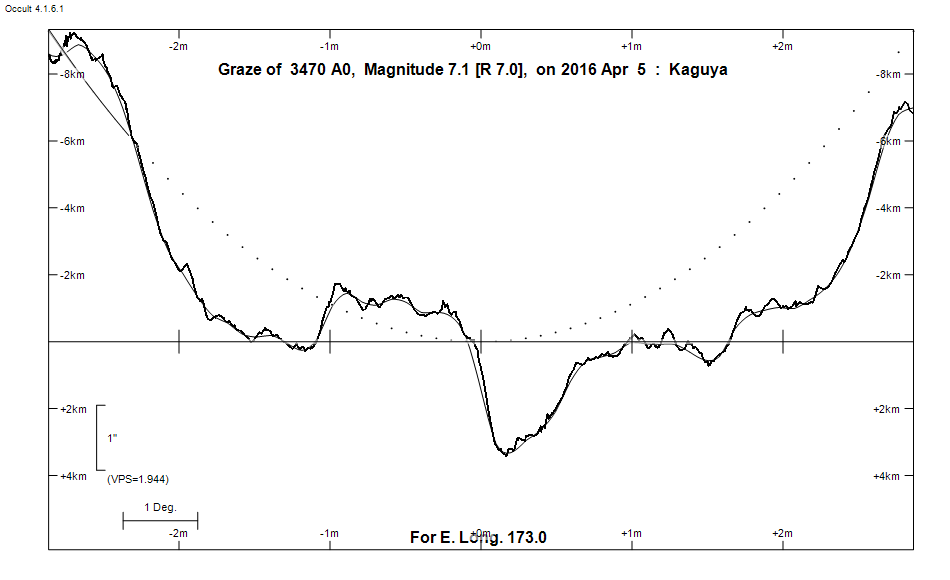
Graze profile
Grazing Occultation of    3470 A0      Magnitude 7.1 [Red = 7.0]
Date: 2016 Apr 05 17h 42m,  to  2016 Apr 05 17h 44m

Nominal site altitude 100m

E. Longit.   Latitude       U.T.    Sun  Moon   TanZ   PA    AA      CA
   o  '  "    o  '   "    h  m  s   Alt Alt Az          o     o      o
 167  0  0  -35 18 26.1  17 41 33        4  90 12.81 162.6 187.40   5.42S
 167 30  0  -35 19 12.1  17 41 35        5  90 11.71 162.5 187.35   5.37S
 168  0  0  -35 19 53.7  17 41 37        5  90 10.79 162.5 187.29   5.31S
 168 30  0  -35 20 31.0  17 41 40        6  90  9.99 162.4 187.23   5.26S
 169  0  0  -35 21  3.9  17 41 43        6  89  9.31 162.4 187.18   5.20S
 169 30  0  -35 21 32.3  17 41 47        7  89  8.71 162.3 187.12   5.14S
 170  0  0  -35 21 56.2  17 41 50        7  89  8.18 162.3 187.06   5.08S
 170 30  0  -35 22 15.7  17 41 54        7  88  7.70 162.2 187.00   5.03S
 171  0  0  -35 22 30.6  17 41 59        8  88  7.28 162.1 186.95   4.97S
 171 30  0  -35 22 40.9  17 42  3        8  88  6.90 162.1 186.89   4.91S
 172  0  0  -35 22 46.5  17 42  8        9  87  6.56 162.0 186.83   4.85S
 172 30  0  -35 22 47.6  17 42 14        9  87  6.25 162.0 186.77   4.79S
 173  0  0  -35 22 43.9  17 42 19       10  87  5.96 161.9 186.71   4.73S
 173 30  0  -35 22 35.5  17 42 25       10  87  5.70 161.8 186.64   4.67S
 174  0  0  -35 22 22.4  17 42 32       10  86  5.46 161.8 186.58   4.60S
 174 30  0  -35 22  4.4  17 42 39       11  86  5.24 161.7 186.52   4.54S
 175  0  0  -35 21 41.6  17 42 46  -12  11  86  5.03 161.6 186.46   4.48S
 175 30  0  -35 21 13.9  17 42 53  -11  12  85  4.84 161.6 186.39   4.41S
 176  0  0  -35 20 41.3  17 43  1  -11  12  85  4.66 161.5 186.33   4.35S
 176 30  0  -35 20  3.7  17 43  9  -10  13  85  4.50 161.5 186.26   4.28S
 177  0  0  -35 19 21.1  17 43 17  -10  13  84  4.34 161.4 186.20   4.22S
 177 30  0  -35 18 33.4  17 43 26  -10  13  84  4.19 161.3 186.13   4.15S
 178  0  0  -35 17 40.6  17 43 36   -9  14  84  4.05 161.3 186.06   4.09S
 178 30  0  -35 16 42.7  17 43 45   -9  14  83  3.92 161.2 186.00   4.02S
 179  0  0  -35 15 39.6  17 43 55   -8  15  83  3.80 161.1 185.93   3.95S

Path coordinates are referred to WGS84 (as used by GPS), with the
nominal site altitude being referenced to Mean Sea Level. The path
is adjusted for the effects of refraction at low moon altitudes.


                Librations  Long -3.23   Lat -0.13
                            P +186.69     D +0.51
      Illumination of moon  4%-
        Elongation of Moon  24
    Vertical Profile Scale  approx. 1.95 km/arcsec at mean distance of moon
   Horizontal Scale Factor  2.03 deg/min


At longitude 173.00:
Limiting Magnitudes for various telescope apertures (in cm)
      CA\Tdia   5    10    15    20    25    30    35
     0.7      6.7   8.2   9.0   9.5   9.9  10.2  10.4
     2.7      6.7   8.2   9.0   9.5   9.9  10.2  10.4
     4.7      6.7   8.2   9.0   9.6  10.0  10.2  10.5
     6.7      6.8   8.2   9.0   9.6  10.0  10.3  10.5
     8.7      6.8   8.2   9.1   9.6  10.0  10.3  10.5

------------------------------------------------------------------------------
Results of Observer Scan                                    UT
Site                              Long.   Lat.   Dist.    h  m  s
Auckland                          174.8  -36.9   170km   17 42 42.8
MidNZ                             173.0  -41.0   624km   17 42 19.5
Lunar Limb Profile