Predictions for Grazing Occultation of ZC2454, 2016 Mar 29
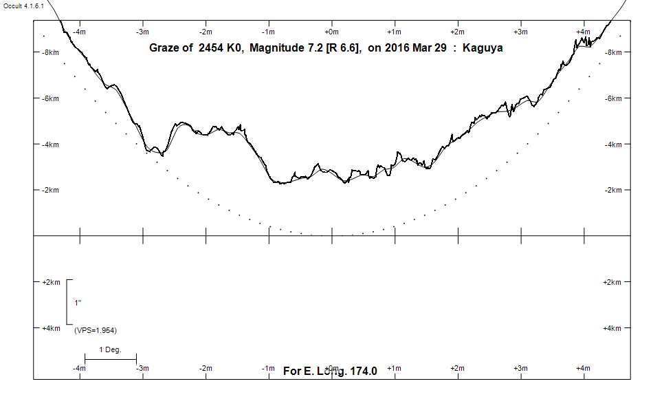
Graze profile
Grazing Occultation of    2454 K0      Magnitude 7.2 [Red = 6.6]
Date: 2016 Mar 29 15h 55m,  to  2016 Mar 29 16h 22m

Nominal site altitude 100m

E. Longit.   Latitude       U.T.    Sun  Moon   TanZ   PA    AA      CA
   o  '  "    o  '   "    h  m  s   Alt Alt Az          o     o      o
 167  0  0  -34 20 41.1  15 54 34       63  57  0.50 191.8 186.32   8.72S
 167 30  0  -34 29 14.3  15 55 42       64  56  0.49 191.7 186.22   8.62S
 168  0  0  -34 37 38.0  15 56 50       64  54  0.48 191.6 186.10   8.51S
 168 30  0  -34 45 52.1  15 57 59       65  53  0.47 191.5 185.99   8.39S
 169  0  0  -34 53 56.5  15 59  7       65  51  0.46 191.4 185.88   8.28S
 169 30  0  -35  1 51.1  16  0 16       66  50  0.45 191.3 185.76   8.16S
 170  0  0  -35  9 35.8  16  1 24       66  48  0.45 191.1 185.64   8.04S
 170 30  0  -35 17 10.6  16  2 33       66  46  0.44 191.0 185.52   7.92S
 171  0  0  -35 24 35.3  16  3 41       67  45  0.43 190.9 185.40   7.80S
 171 30  0  -35 31 49.9  16  4 50       67  43  0.42 190.8 185.28   7.68S
 172  0  0  -35 38 54.4  16  5 58       67  41  0.42 190.7 185.15   7.55S
 172 30  0  -35 45 48.7  16  7  7       68  39  0.41 190.5 185.02   7.43S
 173  0  0  -35 52 32.7  16  8 15       68  38  0.40 190.4 184.90   7.30S
 173 30  0  -35 59  6.4  16  9 23       68  36  0.40 190.3 184.77   7.17S
 174  0  0  -36  5 29.8  16 10 32       69  34  0.39 190.1 184.64   7.04S
 174 30  0  -36 11 42.8  16 11 40       69  32  0.39 190.0 184.50   6.91S
 175  0  0  -36 17 45.4  16 12 48       69  30  0.38 189.9 184.37   6.77S
 175 30  0  -36 23 37.6  16 13 56       69  28  0.38 189.7 184.24   6.64S
 176  0  0  -36 29 19.3  16 15  3       70  26  0.37 189.6 184.10   6.50S
 176 30  0  -36 34 50.6  16 16 11       70  23  0.37 189.5 183.96   6.37S
 177  0  0  -36 40 11.4  16 17 19       70  21  0.37 189.3 183.83   6.23S
 177 30  0  -36 45 21.6  16 18 26       70  19  0.36 189.2 183.69   6.09S
 178  0  0  -36 50 21.4  16 19 33       70  17  0.36 189.1 183.55   5.95S
 178 30  0  -36 55 10.7  16 20 40       70  15  0.36 188.9 183.41   5.81S
 179  0  0  -36 59 49.4  16 21 47       70  13  0.36 188.8 183.27   5.67S

Path coordinates are referred to WGS84 (as used by GPS), with the
nominal site altitude being referenced to Mean Sea Level. The path
is adjusted for the effects of refraction at low moon altitudes.

Projected diameter of star  1 meters  [Estimated]


    C A S S I N I   R E G I O N   G R A Z E
                Librations  Long -6.02   Lat -7.09
                            P +185.62     D -6.29
      Illumination of moon  69%-
        Elongation of Moon  112
    Vertical Profile Scale  approx. 1.98 km/arcsec at mean distance of moon
   Horizontal Scale Factor  1.23 deg/min


At longitude 173.00:
Limiting Magnitudes for various telescope apertures (in cm)
      CA\Tdia   5    10    15    20    25    30    35
     3.3      4.9   6.3   7.1   7.7   8.0   8.3   8.5
     5.3      5.1   6.5   7.3   7.9   8.2   8.5   8.7
     7.3      5.7   7.2   8.0   8.6   8.9   9.2   9.4
     9.3      5.8   7.2   8.0   8.6   9.0   9.2   9.4
    11.3      5.8   7.2   8.0   8.6   9.0   9.2   9.5

------------------------------------------------------------------------------
Results of Observer Scan                                    UT
Site                              Long.   Lat.   Dist.    h  m  s
Auckland                          174.8  -36.9    69km   16 12 20.6
MidNZ                             173.0  -41.0   547km   16  8 15.2
Lunar Limb Profile