Predictions for Grazing Occultation of ZC1941, 2016 Jan 30
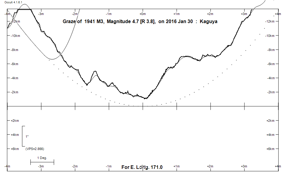
Graze profile
Grazing Occultation of    1941 M3      Magnitude 4.7 [Red = 3.8]  s
   R1941 = 74 Virginis
Date: 2016 Jan 30 14h 50m,  to  2016 Jan 30 15h 16m

Nominal site altitude 100m

E. Longit.   Latitude       U.T.    Sun  Moon   TanZ   PA    AA      CA
   o  '  "    o  '   "    h  m  s   Alt Alt Az          o     o      o
 167  0  0  -42 47 12.1  14 49 41       37  60  1.35 204.5 181.67   4.00S
 167 30  0  -43  2 56.6  14 50 46       37  59  1.33 204.5 181.70   4.03S
 168  0  0  -43 18 46.6  14 51 51       37  58  1.31 204.5 181.73   4.06S
 168 30  0  -43 34 41.4  14 52 57       38  58  1.30 204.6 181.76   4.09S
 169  0  0  -43 50 40.8  14 54  3       38  57  1.28 204.6 181.79   4.12S
 169 30  0  -44  6 44.1  14 55  9       38  56  1.27 204.6 181.82   4.15S
 170  0  0  -44 22 51.0  14 56 16       39  55  1.25 204.6 181.84   4.17S
 170 30  0  -44 39  1.0  14 57 23       39  54  1.24 204.7 181.86   4.19S
 171  0  0  -44 55 13.6  14 58 30       39  53  1.23 204.7 181.88   4.21S
 171 30  0  -45 11 28.4  14 59 37       39  52  1.22 204.7 181.89   4.22S
 172  0  0  -45 27 44.8  15  0 44       40  51  1.20 204.7 181.90   4.23S
 172 30  0  -45 44  2.3  15  1 51       40  50  1.19 204.7 181.91   4.24S
 173  0  0  -46  0 20.4  15  2 58       40  49  1.18 204.7 181.92   4.25S
 173 30  0  -46 16 38.7  15  4  6       40  48  1.18 204.7 181.92   4.25S
 174  0  0  -46 32 56.6  15  5 13       41  47  1.17 204.7 181.92   4.25S
 174 30  0  -46 49 13.7  15  6 20       41  45  1.16 204.7 181.92   4.25S
 175  0  0  -47  5 29.5  15  7 27       41  44  1.15 204.7 181.92   4.25S
 175 30  0  -47 21 43.6  15  8 33       41  43  1.14 204.7 181.91   4.24S
 176  0  0  -47 37 55.5  15  9 40       41  42  1.14 204.7 181.90   4.23S
 176 30  0  -47 54  4.6  15 10 46       41  41  1.13 204.7 181.89   4.22S
 177  0  0  -48 10 10.7  15 11 52       42  40  1.13 204.7 181.88   4.21S
 177 30  0  -48 26 13.3  15 12 57       42  39  1.12 204.7 181.86   4.19S
 178  0  0  -48 42 12.0  15 14  3       42  38  1.12 204.7 181.84   4.17S
 178 30  0  -48 58  6.4  15 15  7       42  37  1.11 204.6 181.82   4.15S
 179  0  0  -49 13 56.1  15 16 12       42  36  1.11 204.6 181.80   4.13S

Path coordinates are referred to WGS84 (as used by GPS), with the
nominal site altitude being referenced to Mean Sea Level. The path
is adjusted for the effects of refraction at low moon altitudes.

Projected diameter of star  14 meters  [CHARM/CADARS, 1 measures]

1941 is variable:
      1941 = NSV 6297, 4.68, range 0.07, V


    C A S S I N I   R E G I O N   G R A Z E
                Librations  Long -1.23   Lat -4.13
                            P +182.01     D -3.83
      Illumination of moon  64%-
        Elongation of Moon  106
    Vertical Profile Scale  approx. 2.77 km/arcsec at mean distance of moon
   Horizontal Scale Factor  1.44 deg/min


At longitude 173.00:
Limiting Magnitudes for various telescope apertures (in cm)
      CA\Tdia   5    10    15    20    25    30    35
     0.2      2.9   4.3   5.1   5.5   5.8   6.0   6.2
     2.2      4.8   6.2   7.0   7.5   7.8   8.0   8.2
     4.2      4.8   6.2   7.0   7.5   7.8   8.1   8.2
     6.2      5.6   7.1   7.9   8.4   8.7   8.9   9.1
     8.2      5.6   7.1   7.9   8.4   8.7   9.0   9.2

------------------------------------------------------------------------------
Results of Observer Scan                                    UT
Site                              Long.   Lat.   Dist.    h  m  s
Chch graze                        172.6  -43.5   202km   15  2  9.7
Dunedin                           170.5  -45.9   107km   14 57 22.4
MidNZ                             173.0  -41.0   451km   15  2 58.5
Lunar Limb Profile