Predictions for Grazing Occultation of ZC2722, 2015 Sep 22
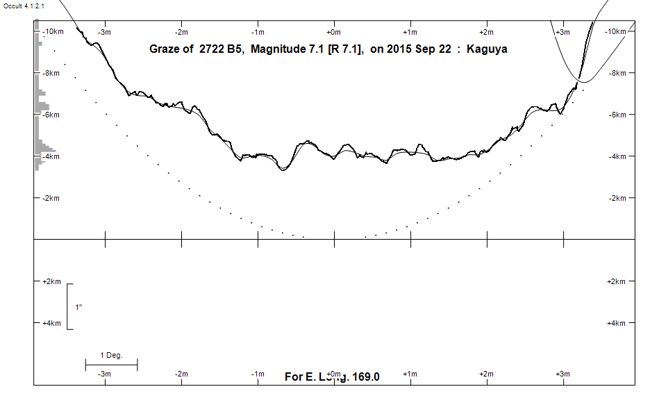
Graze profile
Grazing Occultation of    2722 B5      Magnitude 7.1 [Red = 7.1]
Date: 2015 Sep 22  9h  9m,  to  2015 Sep 22  9h 29m

Nominal site altitude 50m

E. Longit.   Latitude     U.T.    Sun  Moon   TanZ   PA    AA      CA
   o  '  "    o  '  "   h  m  s   Alt Alt Az          o     o      o
 167  0  0  -47  4 53   9  9  7       55 319  0.71 171.9 176.77   4.73S
 167 30  0  -46 58 28   9  9 56       55 317  0.71 171.8 176.70   4.81S
 168  0  0  -46 51 55   9 10 45       54 316  0.72 171.7 176.62   4.88S
 168 30  0  -46 45 15   9 11 34       54 315  0.73 171.7 176.54   4.96S
 169  0  0  -46 38 27   9 12 23       54 314  0.73 171.6 176.47   5.03S
 169 30  0  -46 31 32   9 13 12       53 313  0.74 171.5 176.39   5.11S
 170  0  0  -46 24 30   9 14  1       53 312  0.75 171.4 176.32   5.18S
 170 30  0  -46 17 20   9 14 50       53 311  0.76 171.4 176.25   5.26S
 171  0  0  -46 10  3   9 15 39       53 310  0.76 171.3 176.17   5.33S
 171 30  0  -46  2 38   9 16 28       52 309  0.77 171.2 176.10   5.40S
 172  0  0  -45 55  6   9 17 17       52 308  0.78 171.1 176.03   5.47S
 172 30  0  -45 47 27   9 18  6       52 307  0.79 171.1 175.96   5.54S
 173  0  0  -45 39 40   9 18 55       51 306  0.80 171.0 175.89   5.61S
 173 30  0  -45 31 47   9 19 44       51 305  0.81 170.9 175.83   5.68S
 174  0  0  -45 23 46   9 20 32       51 304  0.82 170.9 175.76   5.74S
 174 30  0  -45 15 38   9 21 21       50 303  0.83 170.8 175.69   5.81S
 175  0  0  -45  7 24   9 22 10       50 302  0.84 170.7 175.63   5.87S
 175 30  0  -44 59  2   9 22 58       50 301  0.85 170.7 175.56   5.94S
 176  0  0  -44 50 33   9 23 47       49 300  0.86 170.6 175.50   6.00S
 176 30  0  -44 41 58   9 24 35       49 299  0.87 170.6 175.44   6.06S
 177  0  0  -44 33 16   9 25 23       49 298  0.88 170.5 175.38   6.12S
 177 30  0  -44 24 27   9 26 11       48 297  0.89 170.4 175.32   6.18S
 178  0  0  -44 15 31   9 26 59       48 296  0.91 170.4 175.26   6.24S
 178 30  0  -44  6 29   9 27 47       47 296  0.92 170.3 175.21   6.29S
 179  0  0  -43 57 21   9 28 35       47 295  0.93 170.3 175.15   6.35S

Path coordinates are referred to WGS84 (as used by GPS), with the
nominal site altitude being referenced to Mean Sea Level. The path
is adjusted for the effects of refraction at low moon altitudes.


    C A S S I N I   R E G I O N   G R A Z E
                Librations  Long -7.74   Lat -7.23
                            P +176.84     D -7.51
      Illumination of moon  60%+
        Elongation of Moon  102
    Vertical Profile Scale  2.19 km/arcsec at mean distance of moon
   Horizontal Scale Factor  1.50 deg/min


At longitude 173.00:
Limiting Magnitudes for various telescope apertures (in cm)
      CA\Tdia   5    10    15    20    25    30    35
     1.6      4.9   6.3   7.1   7.6   8.0   8.2   8.4
     3.6      4.9   6.4   7.1   7.7   8.0   8.3   8.4
     5.6      5.7   7.2   8.0   8.5   8.9   9.2   9.4
     7.6      5.8   7.2   8.0   8.5   8.9   9.2   9.4
     9.6      5.8   7.2   8.0   8.6   8.9   9.2   9.4

------------------------------------------------------------------------------
Results of Observer Scan                                    UT
Site                              Long.   Lat.   Dist.    h  m  s
Chch graze                        172.6  -43.5   232km    9 18 19
Dunedin                           170.5  -45.9    43km    9 14 50
MidNZ                             173.0  -41.0   488km    9 18 55
Lunar Limb Profile