Predictions for Grazing Occultation of SAO 94678, 2015 Jul 13
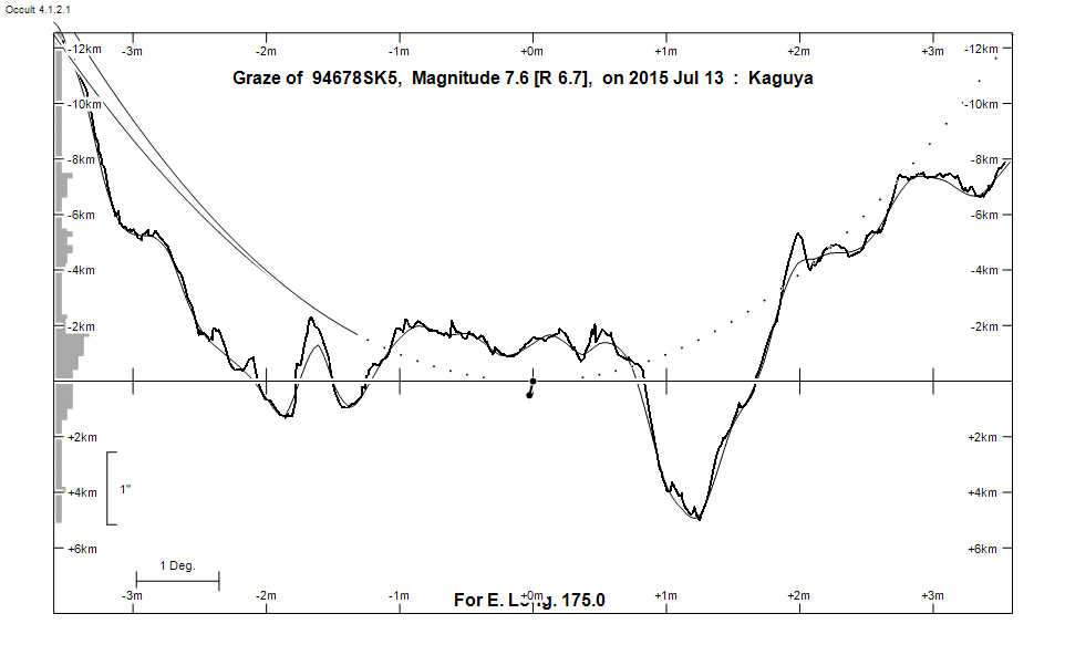
Graze profile
Grazing Occultation of   94678SK5      Magnitude 7.6 [Red = 6.7]
Date: 2015 Jul 13 18h 50m,  to  2015 Jul 13 18h 56m

Nominal site altitude 50m

E. Longit.   Latitude     U.T.    Sun  Moon   TanZ   PA    AA      CA
   o  '  "    o  '  "   h  m  s   Alt Alt Az          o     o      o
 167  0  0  -39 59 20  18 50  0        7  58  8.23 171.5 174.12   2.36S
 167 30  0  -39 47 56  18 50  8        7  58  7.73 171.5 174.11   2.34S
 168  0  0  -39 36 30  18 50 17        8  58  7.28 171.5 174.09   2.32S
 168 30  0  -39 25  2  18 50 26        8  57  6.87 171.5 174.07   2.30S
 169  0  0  -39 13 33  18 50 35        9  57  6.51 171.4 174.05   2.28S
 169 30  0  -39  2  2  18 50 46        9  57  6.18 171.4 174.03   2.27S
 170  0  0  -38 50 30  18 50 57       10  56  5.88 171.4 174.01   2.25S
 170 30  0  -38 38 56  18 51  8  -12  10  56  5.61 171.4 174.00   2.23S
 171  0  0  -38 27 20  18 51 21  -11  11  56  5.35 171.4 173.98   2.22S
 171 30  0  -38 15 43  18 51 34  -11  11  55  5.12 171.4 173.97   2.20S
 172  0  0  -38  4  5  18 51 48  -11  12  55  4.91 171.3 173.96   2.19S
 172 30  0  -37 52 25  18 52  2  -10  12  55  4.71 171.3 173.94   2.18S
 173  0  0  -37 40 45  18 52 17  -10  12  54  4.52 171.3 173.93   2.17S
 173 30  0  -37 29  3  18 52 33   -9  13  54  4.35 171.3 173.92   2.15S
 174  0  0  -37 17 20  18 52 50   -9  13  53  4.19 171.3 173.91   2.14S
 174 30  0  -37  5 37  18 53  7   -8  14  53  4.04 171.3 173.90   2.14S
 175  0  0  -36 53 52  18 53 26   -8  14  53  3.90 171.3 173.89   2.13S
 175 30  0  -36 42  7  18 53 45   -7  15  52  3.76 171.3 173.89   2.12S
 176  0  0  -36 30 23  18 54  5   -7  15  52  3.64 171.3 173.88   2.12S
 176 30  0  -36 18 37  18 54 26   -6  16  52  3.52 171.3 173.88   2.11S
 177  0  0  -36  6 50  18 54 47   -6  16  51  3.41 171.3 173.88   2.11S
 177 30  0  -35 55  4  18 55 10   -5  17  51  3.30 171.3 173.87   2.11S
 178  0  0  -35 43 17  18 55 33   -5  17  50  3.20 171.3 173.87   2.11S
 178 30  0  -35 31 30  18 55 57   -4  18  50  3.10 171.3 173.88   2.11S
 179  0  0  -35 19 44  18 56 22   -3  18  50  3.01 171.3 173.88   2.11S

Path coordinates are referred to WGS84 (as used by GPS), with the
nominal site altitude being referenced to Mean Sea Level. The path
is adjusted for the effects of refraction at low moon altitudes.

Projected diameter of star  5 meters  [Estimated]

94678 is triple:
  This next pair is not confirmed
  ** 7.7 8.7 0.8"  96.0 (OCc1266) Graze path of ? 0.53 km north, and 1.7 secs later compared to the primary
  AB 7.9 9.7 29.8"  59.4 (XMI   9) Graze path of B 29.11 km south, and 62.0 secs later compared to A

                Librations  Long +5.79   Lat +5.81
                            P +174.54     D +6.65
      Illumination of moon  5%-
        Elongation of Moon  27
    Vertical Profile Scale  2.61 km/arcsec at mean distance of moon
   Horizontal Scale Factor  1.64 deg/min


At longitude 173.00:
Limiting Magnitudes for various telescope apertures (in cm)
      CA\Tdia   5    10    15    20    25    30    35
    -1.8      6.4   7.8   8.5   9.0   9.3   9.5   9.7
     0.2      6.5   7.9   8.7   9.2   9.5   9.7   9.9
     2.2      6.5   7.9   8.7   9.2   9.5   9.8   9.9
     4.2      6.5   8.0   8.7   9.2   9.5   9.8   9.9
     6.2      6.5   8.0   8.7   9.2   9.6   9.8   9.9


------------------------------------------------------------------------------
Results of Observer Scan                                    UT
Site                              Long.   Lat.   Dist.    h  m  s
MidNZ                             173.0  -41.0   327km   18 52 17
Lunar Limb Profile