Predictions for Grazing Occultation of SAO139000, 2015 Apr 4
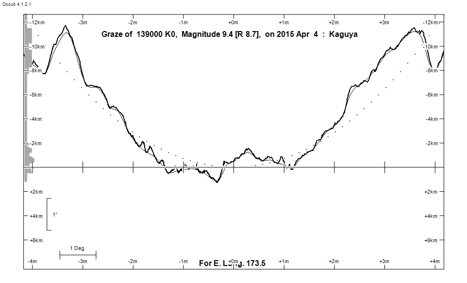
Graze profile
Grazing Occultation of  139000 K0      Magnitude 9.4 [Red = 8.7]
Date: 2015 Apr 04 10h 44m,  to  2015 Apr 04 11h 12m

NB during lunar eclispse

Nominal site altitude 50m

E. Longit.   Latitude     U.T.    Sun  Moon   TanZ   PA    AA      CA
   o  '  "    o  '  "   h  m  s   Alt Alt Az          o     o      o
 167  0  0  -41 57  3  10 44 15       43  47  1.07 205.8 181.44  99.73U
 167 30  0  -42 13 31  10 45 27       43  46  1.06 205.8 181.46  98.37U
 168  0  0  -42 30  2  10 46 39       43  45  1.06 205.8 181.47  97.01U
 168 30  0  -42 46 33  10 47 51       44  44  1.05 205.8 181.48  95.65U
 169  0  0  -43  3  5  10 49  3       44  43  1.04 205.8 181.49  94.29U
 169 30  0  -43 19 36  10 50 15       44  42  1.03 205.8 181.49  92.93U
 170  0  0  -43 36  6  10 51 27       44  40  1.03 205.8 181.49  91.58U
 170 30  0  -43 52 36  10 52 38       44  39  1.02 205.8 181.49  90.23U
 171  0  0  -44  9  4  10 53 49       45  38  1.02 205.8 181.49  88.88U
 171 30  0  -44 25 29  10 55  0       45  37  1.01 205.8 181.48  87.54U
 172  0  0  -44 41 53  10 56 11       45  36  1.01 205.8 181.47  86.21U
 172 30  0  -44 58 13  10 57 21       45  35  1.00 205.8 181.45  84.88U
 173  0  0  -45 14 29  10 58 31       45  33  1.00 205.8 181.44  83.56U
 173 30  0  -45 30 42  10 59 40       45  32  1.00 205.7 181.42  82.22U
 174  0  0  -45 46 51  11  0 49       45  31  1.00 205.7 181.40  80.91U
 174 30  0  -46  2 54  11  1 57       45  30  0.99 205.7 181.37  79.62U
 175  0  0  -46 18 53  11  3  5       45  29  0.99 205.7 181.35  78.34U
 175 30  0  -46 34 46  11  4 12       45  28  0.99 205.6 181.32  77.07U
 176  0  0  -46 50 34  11  5 19       45  26  0.99 205.6 181.29  75.80U
 176 30  0  -47  6 15  11  6 25       45  25  0.99 205.6 181.25  74.56U
 177  0  0  -47 21 50  11  7 31       45  24  0.99 205.5 181.22  73.32U
 177 30  0  -47 37 18  11  8 36       45  23  0.99 205.5 181.18  72.09U
 178  0  0  -47 52 39  11  9 40       45  22  0.99 205.5 181.14  70.88U
 178 30  0  -48  7 53  11 10 43       45  21  1.00 205.4 181.10  69.69U
 179  0  0  -48 23  0  11 11 46       45  19  1.00 205.4 181.06  68.50U

Path coordinates are referred to WGS84 (as used by GPS), with the
nominal site altitude being referenced to Mean Sea Level. The path
is adjusted for the effects of refraction at low moon altitudes.


                Librations  Long -2.82   Lat -1.10
                            P +181.48     D -0.77
      Illumination of moon  46%E
        Elongation of Moon  179
    Vertical Profile Scale  2.63 km/arcsec at mean distance of moon
   Horizontal Scale Factor  1.39 deg/min


At longitude 173.00:
Limiting Magnitudes for various telescope apertures (in cm)
      CA\Tdia   5    10    15    20    25    30    35
    79.6     10.6  11.3  11.9  12.5  13.1  13.8  14.4
    81.6     10.6  11.3  11.9  12.5  13.1  13.8  14.4
    83.6     10.6  11.3  11.9  12.5  13.1  13.8  14.4
    85.6     10.6  11.3  11.9  12.5  13.1  13.8  14.4
    87.6     10.6  11.3  11.9  12.5  13.1  13.8  14.4

------------------------------------------------------------------------------
Results of Observer Scan                                    UT
Site                              Long.   Lat.   Dist.    h  m  s
Chch graze                        172.6  -43.5   135km   10 57 40
Dunedin                           170.5  -45.9   174km   10 52 38
MidNZ                             173.0  -41.0   383km   10 58 31
Lunar Limb Profile