Predictions for Grazing Occultation of ZC2913, 2015 Dec 14
Graze profile
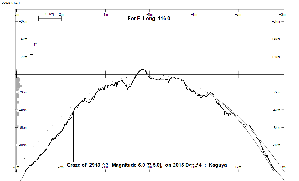
Grazing Occultation of    2913 A2      Magnitude 5.0 [Red = 5.0]
   R2913 = 61 Sagittarii
Date: 2015 Dec 14 11h 44m,  to  2015 Dec 14 11h 55m

Nominal site altitude 50m

E. Longit.   Latitude     U.T.    Sun  Moon   TanZ   PA    AA      CA
   o  '  "    o  '  "   h  m  s   Alt Alt Az          o     o      o
 110  0  0  -35 34 43  11 44 24    0  26 269  2.08 344.1 356.37   2.04N
 110 30  0  -35 22 13  11 44 55    0  25 268  2.13 344.2 356.40   2.07N
 111  0  0  -35  9 45  11 45 26   -1  25 268  2.18 344.2 356.42   2.09N
 111 30  0  -34 57 21  11 45 56   -1  24 267  2.24 344.2 356.45   2.11N
 112  0  0  -34 45  1  11 46 25   -2  24 267  2.29 344.2 356.47   2.14N
 112 30  0  -34 32 44  11 46 53   -3  23 267  2.35 344.3 356.50   2.17N
 113  0  0  -34 20 30  11 47 21   -3  23 266  2.41 344.3 356.52   2.19N
 113 30  0  -34  8 21  11 47 48   -4  22 266  2.48 344.3 356.55   2.22N
 114  0  0  -33 56 15  11 48 14   -4  21 265  2.54 344.3 356.58   2.25N
 114 30  0  -33 44 13  11 48 40   -5  21 265  2.61 344.4 356.61   2.28N
 115  0  0  -33 32 16  11 49  4   -5  20 265  2.68 344.4 356.64   2.31N
 115 30  0  -33 20 22  11 49 28   -6  20 264  2.76 344.4 356.67   2.34N
 116  0  0  -33  8 33  11 49 52   -6  19 264  2.84 344.5 356.70   2.37N
 116 30  0  -32 56 48  11 50 15   -7  19 263  2.92 344.5 356.74   2.41N
 117  0  0  -32 45  7  11 50 36   -7  18 263  3.01 344.5 356.77   2.44N
 117 30  0  -32 33 31  11 50 58   -8  18 263  3.11 344.6 356.80   2.47N
 118  0  0  -32 22  0  11 51 18   -8  17 262  3.20 344.6 356.84   2.51N
 118 30  0  -32 10 34  11 51 38   -9  17 262  3.31 344.6 356.87   2.54N
 119  0  0  -31 59 12  11 51 57   -9  16 262  3.42 344.7 356.91   2.58N
 119 30  0  -31 47 55  11 52 16  -10  16 261  3.54 344.7 356.94   2.62N
 120  0  0  -31 36 43  11 52 34  -10  15 261  3.66 344.7 356.98   2.65N
 120 30  0  -31 25 34  11 52 51  -11  15 261  3.79 344.8 357.02   2.69N
 121  0  0  -31 14 32  11 53  7  -11  14 260  3.93 344.8 357.06   2.73N
 121 30  0  -31  3 34  11 53 23  -12  14 260  4.09 344.9 357.10   2.77N
 122  0  0  -30 52 42  11 53 38       13 260  4.25 344.9 357.13   2.80N
 122 30  0  -30 41 55  11 53 53       13 259  4.42 344.9 357.17   2.84N
 123  0  0  -30 31 13  11 54  7       12 259  4.61 345.0 357.21   2.88N
 123 30  0  -30 20 36  11 54 20       12 259  4.82 345.0 357.25   2.92N
 124  0  0  -30 10  4  11 54 32       11 259  5.04 345.1 357.29   2.96N
 124 30  0  -29 59 37  11 54 44       11 258  5.28 345.1 357.33   3.00N
 125  0  0  -29 49 16  11 54 55       10 258  5.54 345.1 357.37   3.05N

Path coordinates are referred to WGS84 (as used by GPS), with the
nominal site altitude being referenced to Mean Sea Level. The path
is adjusted for the effects of refraction at low moon altitudes.


                Librations  Long -5.16   Lat -6.12
                            P +357.37     D +6.66
      Illumination of moon  10%+
        Elongation of Moon  37
    Vertical Profile Scale  2.31 km/arcsec at mean distance of moon
   Horizontal Scale Factor  1.93 deg/min


At longitude 117.50:
Limiting Magnitudes for various telescope apertures (in cm)
      CA\Tdia   5    10    15    20    25    30    35
    -1.5      5.2   6.6   7.4   7.8   8.1   8.3   8.5
     0.5      5.4   6.8   7.6   8.1   8.4   8.6   8.7
     2.5      5.4   6.8   7.6   8.1   8.4   8.6   8.8
     4.5      5.4   6.8   7.6   8.1   8.4   8.6   8.8
     6.5      5.4   6.8   7.6   8.1   8.4   8.6   8.8

------------------------------------------------------------------------------
Results of Observer Scan                                    UT
Site                              Long.   Lat.   Dist.    h  m  s
Greg Bolt, Craigie, W Aus         115.8  -31.8   146km   11 49 41
Jacqeline Milner                  116.1  -31.9   121km   11 49 56
Lunar Limb Profile