Predictions for Grazing Occultation of ZC3269, 2015 Oct 23
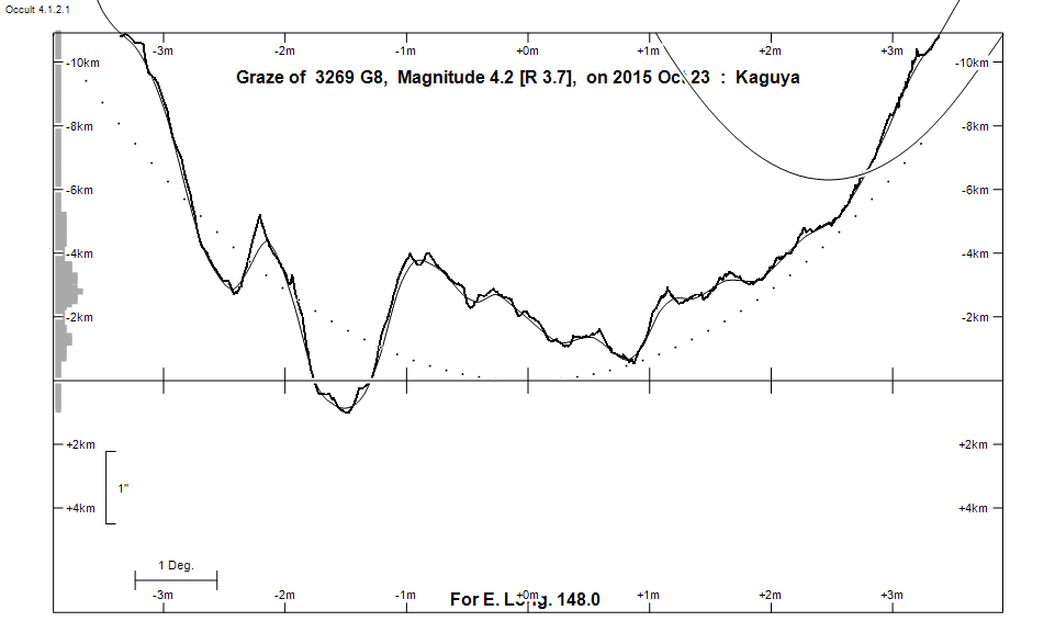
Graze profile
Grazing Occultation of    3269 G8      Magnitude 4.2 [Red = 3.7]
   R3269 = Ancha = theta Aquarii
Date: 2015 Oct 23 10h 33m,  to  2015 Oct 23 11h 11m

Nominal site altitude 50m

E. Longit.   Latitude     U.T.    Sun  Moon   TanZ   PA    AA      CA
   o  '  "    o  '  "   h  m  s   Alt Alt Az          o     o      o
 135  0  0  -46 53 13  10 32 48   -9  50  15  0.84 157.5 179.94   3.45S
 135 30  0  -46 43 32  10 33 35  -10  50  14  0.83 157.4 179.86   3.53S
 136  0  0  -46 33 42  10 34 23  -10  51  13  0.82 157.4 179.79   3.60S
 136 30  0  -46 23 42  10 35 11  -11  51  12  0.81 157.3 179.71   3.68S
 137  0  0  -46 13 34  10 35 59  -11  51  11  0.80 157.2 179.63   3.76S
 137 30  0  -46  3 17  10 36 48  -12  51  10  0.80 157.1 179.55   3.84S
 138  0  0  -45 52 50  10 37 38       52   9  0.79 157.0 179.47   3.91S
 138 30  0  -45 42 15  10 38 28       52   8  0.78 157.0 179.40   3.99S
 139  0  0  -45 31 31  10 39 19       52   7  0.78 156.9 179.32   4.07S
 139 30  0  -45 20 37  10 40 10       52   5  0.77 156.8 179.24   4.14S
 140  0  0  -45  9 34  10 41  2       53   4  0.76 156.7 179.17   4.22S
 140 30  0  -44 58 22  10 41 55       53   3  0.76 156.7 179.09   4.29S
 141  0  0  -44 47  1  10 42 48       53   2  0.75 156.6 179.02   4.37S
 141 30  0  -44 35 31  10 43 42       53   1  0.75 156.5 178.95   4.44S
 142  0  0  -44 23 51  10 44 36       53 360  0.74 156.4 178.87   4.51S
 142 30  0  -44 12  3  10 45 31       54 358  0.74 156.4 178.80   4.59S
 143  0  0  -44  0  5  10 46 27       54 357  0.73 156.3 178.73   4.66S
 143 30  0  -43 47 59  10 47 23       54 356  0.73 156.2 178.66   4.73S
 144  0  0  -43 35 43  10 48 20       54 355  0.72 156.2 178.59   4.80S
 144 30  0  -43 23 18  10 49 17       54 353  0.72 156.1 178.52   4.87S
 145  0  0  -43 10 45  10 50 15       54 352  0.71 156.0 178.45   4.93S
 145 30  0  -42 58  2  10 51 13       55 351  0.71 156.0 178.39   5.00S
 146  0  0  -42 45 11  10 52 12       55 349  0.71 155.9 178.32   5.06S
 146 30  0  -42 32 11  10 53 12       55 348  0.70 155.8 178.26   5.13S
 147  0  0  -42 19  2  10 54 12       55 347  0.70 155.8 178.20   5.19S
 147 30  0  -42  5 45  10 55 12       55 345  0.70 155.7 178.14   5.25S
 148  0  0  -41 52 20  10 56 13       55 344  0.70 155.6 178.08   5.31S
 148 30  0  -41 38 46  10 57 15       55 343  0.70 155.6 178.02   5.37S
 149  0  0  -41 25  4  10 58 17       55 341  0.70 155.5 177.96   5.42S
 149 30  0  -41 11 15  10 59 20       55 340  0.70 155.5 177.91   5.48S
 150  0  0  -40 57 17  11  0 23       55 338  0.70 155.4 177.85   5.53S
 150 30  0  -40 43 12  11  1 27       55 337  0.70 155.4 177.80   5.58S
 151  0  0  -40 28 59  11  2 31       55 336  0.70 155.3 177.75   5.63S
 151 30  0  -40 14 39  11  3 36       55 334  0.70 155.3 177.70   5.68S
 152  0  0  -40  0 12  11  4 41       55 333  0.70 155.2 177.66   5.73S
 152 30  0  -39 45 38  11  5 46       55 331  0.70 155.2 177.62   5.77S
 153  0  0  -39 30 58  11  6 52       55 330  0.70 155.1 177.57   5.81S
 153 30  0  -39 16 11  11  7 58       55 329  0.70 155.1 177.54   5.85S
 154  0  0  -39  1 18  11  9  5       55 327  0.71 155.1 177.50   5.89S
 154 30  0  -38 46 19  11 10 12       55 326  0.71 155.0 177.46   5.92S
 155  0  0  -38 31 15  11 11 19       54 324  0.71 155.0 177.43   5.95S

Path coordinates are referred to WGS84 (as used by GPS), with the
nominal site altitude being referenced to Mean Sea Level. The path
is adjusted for the effects of refraction at low moon altitudes.

Projected diameter of star  5 meters  [CHARM/CADARS, 6 measures]


    C A S S I N I   R E G I O N   G R A Z E
                Librations  Long -4.64   Lat -3.65
                            P +178.73     D -3.51
      Illumination of moon  78%+
        Elongation of Moon  124
    Vertical Profile Scale  2.27 km/arcsec at mean distance of moon
   Horizontal Scale Factor  1.49 deg/min


At longitude 145.00:
Limiting Magnitudes for various telescope apertures (in cm)
      CA\Tdia   5    10    15    20    25    30    35
     0.9      2.8   4.2   4.9   5.4   5.8   6.0   6.1
     2.9      4.4   5.9   6.7   7.2   7.5   7.8   7.9
     4.9      4.7   6.2   7.0   7.5   7.8   8.1   8.3
     6.9      5.0   6.5   7.3   7.8   8.1   8.4   8.6
     8.9      5.6   7.1   7.9   8.4   8.8   9.0   9.2

------------------------------------------------------------------------------
Results of Observer Scan                                    UT
Site                              Long.   Lat.   Dist.    h  m  s
Hobart                            147.3  -42.9    66km   10 54 48
Lunar Limb Profile