Predictions for Grazing Occultation of ZC 764, 2015 Sep 5
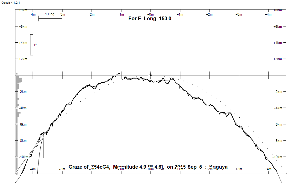
Graze profile
Grazing Occultation of     764cG4      Magnitude 4.9 [Red = 4.6]
   R764 = 104 Tauri
Date: 2015 Sep 05 18h 13m,  to  2015 Sep 05 18h 47m

Nominal site altitude 50m

E. Longit.   Latitude     U.T.    Sun  Moon   TanZ   PA    AA      CA
   o  '  "    o  '  "   h  m  s   Alt Alt Az          o     o      o
 135  0  0  -33 58 12  18 13  9       23  46  2.39 348.3 353.74   6.25N
 135 30  0  -33 45 36  18 13 42       23  45  2.33 348.3 353.74   6.26N
 136  0  0  -33 33  1  18 14 15       24  45  2.27 348.3 353.74   6.25N
 136 30  0  -33 20 26  18 14 50       24  44  2.22 348.3 353.75   6.25N
 137  0  0  -33  7 51  18 15 25       25  44  2.17 348.3 353.75   6.24N
 137 30  0  -32 55 17  18 16  1       25  44  2.11 348.3 353.76   6.23N
 138  0  0  -32 42 44  18 16 39       26  43  2.06 348.3 353.77   6.22N
 138 30  0  -32 30 11  18 17 17       26  43  2.02 348.3 353.79   6.21N
 139  0  0  -32 17 40  18 17 56       27  42  1.97 348.3 353.80   6.19N
 139 30  0  -32  5 11  18 18 36       27  42  1.93 348.3 353.82   6.18N
 140  0  0  -31 52 43  18 19 17       28  41  1.88 348.4 353.84   6.16N
 140 30  0  -31 40 17  18 19 59       29  41  1.84 348.4 353.86   6.13N
 141  0  0  -31 27 53  18 20 42       29  40  1.80 348.4 353.89   6.11N
 141 30  0  -31 15 31  18 21 26       30  39  1.76 348.4 353.92   6.08N
 142  0  0  -31  3 12  18 22 11       30  39  1.72 348.5 353.95   6.05N
 142 30  0  -30 50 56  18 22 56       31  38  1.69 348.5 353.98   6.02N
 143  0  0  -30 38 44  18 23 43       31  38  1.65 348.5 354.01   5.98N
 143 30  0  -30 26 34  18 24 31       32  37  1.62 348.6 354.05   5.95N
 144  0  0  -30 14 29  18 25 20       32  37  1.59 348.6 354.09   5.90N
 144 30  0  -30  2 27  18 26  9       33  36  1.56 348.7 354.14   5.86N
 145  0  0  -29 50 30  18 27  0       33  35  1.52 348.7 354.19   5.81N
 145 30  0  -29 38 37  18 27 51       34  35  1.49 348.8 354.24   5.76N
 146  0  0  -29 26 49  18 28 44       34  34  1.47 348.8 354.29   5.71N
 146 30  0  -29 15  7  18 29 38       35  34  1.44 348.9 354.35   5.65N
 147  0  0  -29  3 30  18 30 32       35  33  1.41 348.9 354.41   5.59N
 147 30  0  -28 51 59  18 31 27       36  32  1.38 349.0 354.47   5.53N
 148  0  0  -28 40 34  18 32 24       36  32  1.36 349.1 354.54   5.46N
 148 30  0  -28 29 16  18 33 21       37  31  1.34 349.1 354.61   5.39N
 149  0  0  -28 18  5  18 34 19       37  30  1.31 349.2 354.68   5.31N
 149 30  0  -28  7  1  18 35 18       38  29  1.29 349.3 354.76   5.24N
 150  0  0  -27 56  5  18 36 18       38  29  1.27 349.4 354.85   5.15N
 150 30  0  -27 45 18  18 37 19       39  28  1.25 349.5 354.93   5.07N
 151  0  0  -27 34 38  18 38 21       39  27  1.22 349.5 355.02   4.98N
 151 30  0  -27 24  7  18 39 24       40  26  1.20 349.6 355.11   4.89N
 152  0  0  -27 13 46  18 40 27       40  26  1.19 349.7 355.21   4.79N
 152 30  0  -27  3 34  18 41 32       41  25  1.17 349.8 355.31   4.69N
 153  0  0  -26 53 32  18 42 37       41  24  1.15 349.9 355.42   4.58N
 153 30  0  -26 43 41  18 43 43       41  23  1.13 350.1 355.53   4.47N
 154  0  0  -26 34  0  18 44 49       42  22  1.12 350.2 355.64   4.36N
 154 30  0  -26 24 30  18 45 57       42  21  1.10 350.3 355.76   4.24N
 155  0  0  -26 15 12  18 47  5       43  21  1.08 350.4 355.88   4.12N

Path coordinates are referred to WGS84 (as used by GPS), with the
nominal site altitude being referenced to Mean Sea Level. The path
is adjusted for the effects of refraction at low moon altitudes.

Projected diameter of star  2 meters  [Estimated]

764 is double:
  AB 5.8 5.8 0.10"  55.6 (A  3010) Graze path of B 0.10 km south, and 0.3 secs later compared to A

    C A S S I N I   R E G I O N   G R A Z E
                Librations  Long +7.84   Lat +5.97
                            P +354.99     D -6.48
      Illumination of moon  46%-
        Elongation of Moon  85
    Vertical Profile Scale  2.52 km/arcsec at mean distance of moon
   Horizontal Scale Factor  1.36 deg/min


At longitude 145.00:
Limiting Magnitudes for various telescope apertures (in cm)
      CA\Tdia   5    10    15    20    25    30    35
     1.8      4.9   6.3   7.1   7.6   7.9   8.1   8.3
     3.8      5.6   7.1   7.9   8.4   8.7   9.0   9.1
     5.8      5.7   7.1   7.9   8.4   8.8   9.0   9.2
     7.8      5.7   7.2   7.9   8.5   8.8   9.1   9.2
     9.8      5.7   7.2   8.0   8.5   8.8   9.1   9.3

------------------------------------------------------------------------------
Results of Observer Scan                                    UT
Site                              Long.   Lat.   Dist.    h  m  s
AU Mid                            143.0  -30.6     5km   18 23 43
Brisbane                          153.1  -27.5    62km   18 42 43
Bundaberg                         152.3  -24.8   241km   18 41 10
Lunar Limb Profile