Predictions for Grazing Occultation of ZC2097, 2015 Aug 21
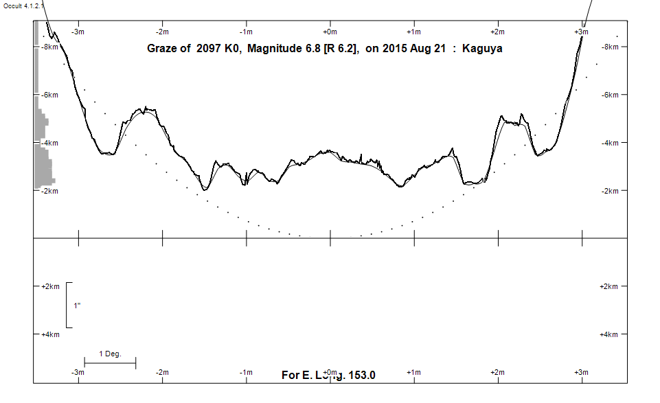
Graze profile
Grazing Occultation of    2097 K0      Magnitude 6.8 [Red = 6.2]
Date: 2015 Aug 21 10h 59m,  to  2015 Aug 21 11h 19m

Nominal site altitude 50m

E. Longit.   Latitude     U.T.    Sun  Moon   TanZ   PA    AA      CA
   o  '  "    o  '  "   h  m  s   Alt Alt Az          o     o      o
 135  0  0  -28 32 54  10 58 59       42 279  1.11 193.6 174.88   2.89S
 135 30  0  -28 32 53  10 59 41       42 279  1.13 193.5 174.76   3.01S
 136  0  0  -28 32 43  11  0 23       41 279  1.15 193.4 174.64   3.13S
 136 30  0  -28 32 24  11  1  3       40 278  1.18 193.3 174.52   3.25S
 137  0  0  -28 31 58  11  1 43       40 278  1.20 193.2 174.40   3.37S
 137 30  0  -28 31 24  11  2 23       39 277  1.23 193.0 174.28   3.49S
 138  0  0  -28 30 42  11  3  2       39 277  1.25 192.9 174.17   3.60S
 138 30  0  -28 29 52  11  3 40       38 277  1.28 192.8 174.05   3.72S
 139  0  0  -28 28 54  11  4 17       37 276  1.30 192.7 173.94   3.83S
 139 30  0  -28 27 49  11  4 54       37 276  1.33 192.6 173.83   3.94S
 140  0  0  -28 26 37  11  5 31       36 275  1.36 192.5 173.72   4.05S
 140 30  0  -28 25 17  11  6  6       36 275  1.39 192.4 173.61   4.16S
 141  0  0  -28 23 50  11  6 41       35 275  1.42 192.3 173.51   4.26S
 141 30  0  -28 22 16  11  7 16       35 274  1.45 192.2 173.40   4.37S
 142  0  0  -28 20 35  11  7 50       34 274  1.48 192.1 173.30   4.47S
 142 30  0  -28 18 46  11  8 23       34 274  1.51 192.0 173.20   4.57S
 143  0  0  -28 16 51  11  8 55       33 273  1.54 191.9 173.10   4.67S
 143 30  0  -28 14 49  11  9 27       32 273  1.57 191.8 173.00   4.77S
 144  0  0  -28 12 41  11  9 59       32 273  1.61 191.7 172.91   4.86S
 144 30  0  -28 10 26  11 10 30       31 272  1.64 191.6 172.81   4.96S
 145  0  0  -28  8  4  11 11  0       31 272  1.68 191.5 172.72   5.05S
 145 30  0  -28  5 36  11 11 30       30 272  1.72 191.4 172.62   5.14S
 146  0  0  -28  3  2  11 11 59       30 271  1.76 191.3 172.53   5.23S
 146 30  0  -28  0 22  11 12 27       29 271  1.79 191.2 172.44   5.32S
 147  0  0  -27 57 35  11 12 55       29 271  1.84 191.1 172.36   5.41S
 147 30  0  -27 54 42  11 13 22       28 270  1.88 191.0 172.27   5.50S
 148  0  0  -27 51 43  11 13 49       27 270  1.92 191.0 172.19   5.58S
 148 30  0  -27 48 39  11 14 15       27 270  1.97 190.9 172.10   5.67S
 149  0  0  -27 45 29  11 14 41       26 270  2.01 190.8 172.02   5.75S
 149 30  0  -27 42 13  11 15  6       26 269  2.06 190.7 171.94   5.83S
 150  0  0  -27 38 51  11 15 30       25 269  2.11 190.6 171.86   5.91S
 150 30  0  -27 35 24  11 15 54       25 269  2.16 190.6 171.78   5.99S
 151  0  0  -27 31 51  11 16 17       24 268  2.22 190.5 171.70   6.06S
 151 30  0  -27 28 13  11 16 40       24 268  2.27 190.4 171.63   6.14S
 152  0  0  -27 24 29  11 17  2       23 268  2.33 190.3 171.55   6.21S
 152 30  0  -27 20 41  11 17 24       23 267  2.39 190.3 171.48   6.29S
 153  0  0  -27 16 47  11 17 45       22 267  2.45 190.2 171.41   6.36S
 153 30  0  -27 12 48  11 18  6       22 267  2.52 190.1 171.34   6.43S
 154  0  0  -27  8 44  11 18 26       21 267  2.59 190.0 171.27   6.50S
 154 30  0  -27  4 35  11 18 45       21 266  2.66 190.0 171.20   6.57S
 155  0  0  -27  0 22  11 19  4       20 266  2.73 189.9 171.13   6.63S

Path coordinates are referred to WGS84 (as used by GPS), with the
nominal site altitude being referenced to Mean Sea Level. The path
is adjusted for the effects of refraction at low moon altitudes.

Projected diameter of star  2 meters  [Estimated]


    C A S S I N I   R E G I O N   G R A Z E
                Librations  Long -6.26   Lat -4.55
                            P +173.20     D -5.05
      Illumination of moon  36%+
        Elongation of Moon  74
    Vertical Profile Scale  1.89 km/arcsec at mean distance of moon
   Horizontal Scale Factor  1.52 deg/min


At longitude 145.00:
Limiting Magnitudes for various telescope apertures (in cm)
      CA\Tdia   5    10    15    20    25    30    35
     1.1      4.9   6.4   7.1   7.6   8.0   8.2   8.4
     3.1      5.0   6.4   7.2   7.6   8.0   8.2   8.4
     5.1      5.7   7.2   8.0   8.5   8.8   9.1   9.3
     7.1      5.8   7.2   8.0   8.5   8.9   9.1   9.3
     9.1      5.8   7.2   8.0   8.5   8.9   9.2   9.3

------------------------------------------------------------------------------
Results of Observer Scan                                    UT
Site                              Long.   Lat.   Dist.    h  m  s
AU Mid                            143.0  -30.6   257km   11  8 55
Brisbane                          153.1  -27.5    21km   11 17 47
Lunar Limb Profile