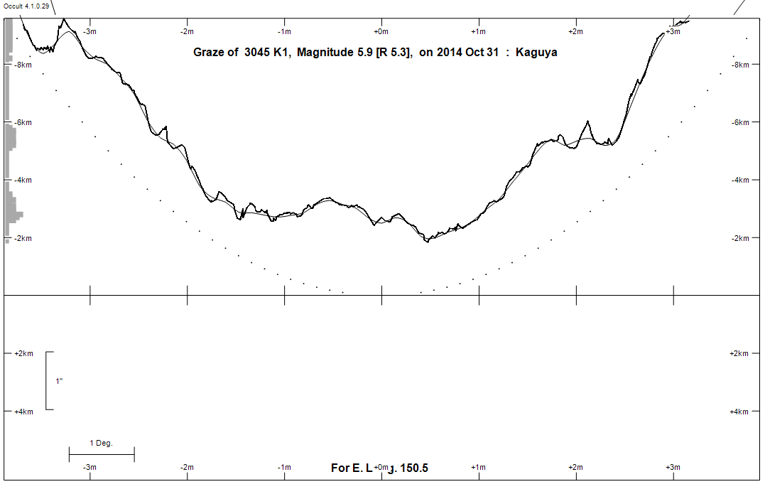
Predictions for Grazing Occultation of ZC 3045, 2014 Oct 31, Rockhampton, Qld
Graze profile Rockhampton
Grazing Occultation of    3045 K1      Magnitude 5.9 [Red = 5.3]
Date: 2014 Oct 31  9h 59m,  to  2014 Oct 31 10h 52m

Nominal site altitude 100m

E. Longit.   Latitude     U.T.    Sun  Moon   TanZ   PA    AA      CA
   o  '  "    o  '  "   h  m  s   Alt Alt Az          o     o      o
 133  0  0  -31 54  0   9 59  1   -6  69 333  0.39 157.4 173.78   7.21S
 133 30  0  -31 41 18  10  0 14   -7  69 331  0.39 157.3 173.69   7.30S
 134  0  0  -31 28 26  10  1 27   -8  69 329  0.39 157.2 173.60   7.39S
 134 30  0  -31 15 25  10  2 40   -8  68 327  0.40 157.1 173.51   7.48S
 135  0  0  -31  2 14  10  3 53   -9  68 325  0.40 157.1 173.43   7.56S
 135 30  0  -30 48 54  10  5  7  -10  68 322  0.41 157.0 173.34   7.64S
 136  0  0  -30 35 24  10  6 21  -11  68 320  0.41 156.9 173.26   7.72S
 136 30  0  -30 21 46  10  7 36  -11  67 318  0.42 156.8 173.19   7.80S
 137  0  0  -30  7 59  10  8 51       67 316  0.42 156.7 173.11   7.87S
 137 30  0  -29 54  3  10 10  5       67 314  0.43 156.7 173.04   7.94S
 138  0  0  -29 39 59  10 11 21       66 312  0.44 156.6 172.98   8.01S
 138 30  0  -29 25 47  10 12 36       66 311  0.44 156.5 172.90   8.08S
 139  0  0  -29 11 27  10 13 51       66 309  0.45 156.5 172.84   8.15S
 139 30  0  -28 57  0  10 15  7       65 307  0.46 156.4 172.78   8.20S
 140  0  0  -28 42 26  10 16 22       65 305  0.47 156.4 172.73   8.26S
 140 30  0  -28 27 45  10 17 38       64 304  0.48 156.3 172.68   8.31S
 141  0  0  -28 12 57  10 18 53       64 302  0.49 156.3 172.63   8.36S
 141 30  0  -27 58  3  10 20  9       63 300  0.50 156.2 172.58   8.40S
 142  0  0  -27 43  3  10 21 25       63 299  0.51 156.2 172.54   8.45S
 142 30  0  -27 27 58  10 22 40       62 297  0.52 156.1 172.50   8.49S
 143  0  0  -27 12 47  10 23 55       62 296  0.54 156.1 172.46   8.52S
 143 30  0  -26 57 32  10 25 11       61 295  0.55 156.1 172.43   8.56S
 144  0  0  -26 42 12  10 26 26       61 293  0.56 156.0 172.40   8.59S
 144 30  0  -26 26 48  10 27 40       60 292  0.57 156.0 172.37   8.61S
 145  0  0  -26 11 21  10 28 55       60 291  0.59 156.0 172.35   8.63S
 145 30  0  -25 55 50  10 30  9       59 290  0.60 156.0 172.33   8.65S
 146  0  0  -25 40 16  10 31 23       58 289  0.62 155.9 172.31   8.67S
 146 30  0  -25 24 40  10 32 37       58 287  0.63 155.9 172.30   8.68S
 147  0  0  -25  9  1  10 33 50       57 286  0.65 155.9 172.29   8.69S
 147 30  0  -24 53 21  10 35  3       56 285  0.66 155.9 172.29   8.70S
 148  0  0  -24 37 39  10 36 15       56 284  0.68 155.9 172.28   8.70S
 148 30  0  -24 21 57  10 37 27       55 283  0.70 155.9 172.28   8.70S
 149  0  0  -24  6 13  10 38 39       55 282  0.71 155.9 172.29   8.70S
 149 30  0  -23 50 30  10 39 50       54 282  0.73 155.9 172.29   8.69S
 150  0  0  -23 34 47  10 41  0       53 281  0.75 155.9 172.30   8.68S
 150 30  0  -23 19  4  10 42 10       53 280  0.77 155.9 172.31   8.67S
 151  0  0  -23  3 22  10 43 19       52 279  0.78 156.0 172.33   8.66S
 151 30  0  -22 47 41  10 44 27       51 278  0.80 156.0 172.35   8.64S
 152  0  0  -22 32  2  10 45 35       51 278  0.82 156.0 172.37   8.62S
 152 30  0  -22 16 25  10 46 42       50 277  0.84 156.0 172.39   8.59S
 153  0  0  -22  0 51  10 47 48       49 276  0.86 156.0 172.42   8.57S
 153 30  0  -21 45 19  10 48 54       48 276  0.89 156.1 172.45   8.54S
 154  0  0  -21 29 50  10 49 58       48 275  0.91 156.1 172.48   8.51S
 154 30  0  -21 14 24  10 51  2       47 274  0.93 156.1 172.51   8.47S
 155  0  0  -20 59  2  10 52  5       46 274  0.95 156.2 172.55   8.43S

Path coordinates are referred to WGS84 (as used by GPS), with the
nominal site altitude being referenced to Mean Sea Level. The path
is adjusted for the effects of refraction at low moon altitudes.

Projected diameter of star  3 meters  [Estimated]


    C A S S I N I   R E G I O N   G R A Z E
                Librations  Long -2.15   Lat -6.62
                            P +172.59     D -6.58
      Illumination of moon  53%+
        Elongation of Moon  94
    Vertical Profile Scale  2.00 km/arcsec at mean distance of moon
   Horizontal Scale Factor  1.42 deg/min


At longitude 144.00:
Limiting Magnitudes for various telescope apertures (in cm)
      CA\Tdia   5    10    15    20    25    30    35
     4.6      5.8   7.3   8.1   8.7   9.0   9.3   9.5
     6.6      5.9   7.3   8.1   8.7   9.1   9.3   9.6
     8.6      5.9   7.3   8.2   8.7   9.1   9.4   9.6
    10.6      5.9   7.3   8.2   8.7   9.1   9.4   9.6
    12.6      5.9   7.4   8.2   8.7   9.1   9.4   9.6

------------------------------------------------------------------------------
Results of Observer Scan                                    UT
Site                              Long.   Lat.   Dist.    h  m  s
Bundaberg                         152.3  -24.8   235km   10 46 19
Rockhampton                       150.5  -23.4     5km   10 42  9
Lunar Limb Profile - Rockhampton.