Predictions for Grazing Occultation of ZC 132, 2014 Oct 8, Launceston, Tasmania
Graze profile Tasmania
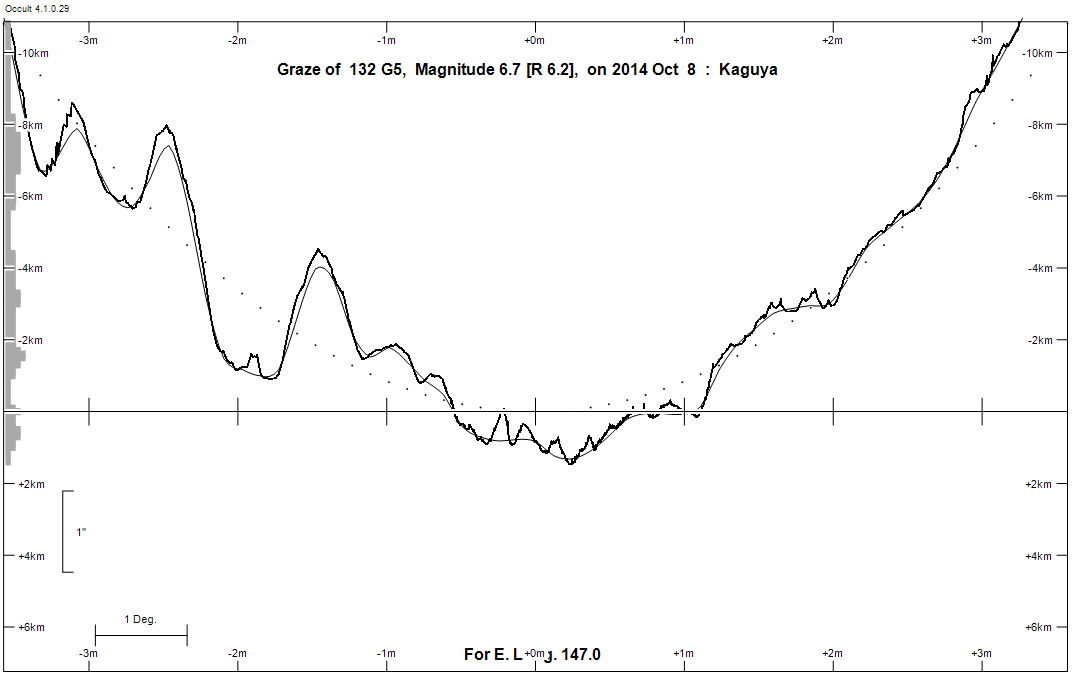
Grazing Occultation of     132 G5      Magnitude 6.7 [Red = 6.2]
Date: 2014 Oct 08 11h 30m,  to  2014 Oct 08 11h 50m

Nominal site altitude 100m

E. Longit.   Latitude     U.T.    Sun  Moon   TanZ   PA    AA      CA
   o  '  "    o  '  "   h  m  s   Alt Alt Az          o     o      o
 133  0  0  -46  7 58  11 29 37       20  57  2.82 157.1 181.22  50.85U
 133 30  0  -45 59 30  11 29 53       20  56  2.75 157.0 181.16  51.22U
 134  0  0  -45 50 55  11 30  9       20  56  2.69 156.9 181.09  51.60U
 134 30  0  -45 42 13  11 30 25       21  55  2.64 156.9 181.02  51.99U
 135  0  0  -45 33 25  11 30 42       21  55  2.58 156.8 180.96  52.39U
 135 30  0  -45 24 31  11 31  0       22  54  2.53 156.7 180.89  52.80U
 136  0  0  -45 15 29  11 31 18       22  54  2.47 156.7 180.82  53.22U
 136 30  0  -45  6 21  11 31 37       22  53  2.42 156.6 180.75  53.65U
 137  0  0  -44 57  6  11 31 56       23  53  2.37 156.5 180.69  54.10U
 137 30  0  -44 47 45  11 32 15       23  53  2.32 156.5 180.62  54.55U
 138  0  0  -44 38 16  11 32 36       24  52  2.28 156.4 180.55  55.01U
 138 30  0  -44 28 41  11 32 56       24  52  2.23 156.3 180.48  55.49U
 139  0  0  -44 18 58  11 33 17       25  51  2.19 156.3 180.41  55.98U
 139 30  0  -44  9  9  11 33 39       25  51  2.14 156.2 180.34  56.48U
 140  0  0  -43 59 12  11 34  1       25  50  2.10 156.1 180.27  56.99U
 140 30  0  -43 49  8  11 34 24       26  50  2.06 156.1 180.20  57.51U
 141  0  0  -43 38 57  11 34 48       26  49  2.02 156.0 180.13  58.05U
 141 30  0  -43 28 39  11 35 12       27  49  1.98 155.9 180.06  58.60U
 142  0  0  -43 18 13  11 35 37       27  48  1.95 155.8 179.99  59.16U
 142 30  0  -43  7 40  11 36  2       28  48  1.91 155.8 179.92  59.73U
 143  0  0  -42 57  0  11 36 28       28  47  1.87 155.7 179.85  60.32U
 143 30  0  -42 46 12  11 36 54       29  47  1.84 155.6 179.78  60.92U
 144  0  0  -42 35 16  11 37 22       29  46  1.80 155.6 179.71  61.54U
 144 30  0  -42 24 13  11 37 49       29  46  1.77 155.5 179.63  62.17U
 145  0  0  -42 13  3  11 38 18       30  45  1.74 155.4 179.56  62.81U
 145 30  0  -42  1 45  11 38 47       30  45  1.71 155.3 179.49  63.47U
 146  0  0  -41 50 19  11 39 17       31  44  1.68 155.3 179.42  64.14U
 146 30  0  -41 38 45  11 39 47       31  44  1.64 155.2 179.35  64.83U
 147  0  0  -41 27  3  11 40 19       32  43  1.61 155.1 179.28  65.53U
 147 30  0  -41 15 14  11 40 51       32  42  1.59 155.1 179.20  66.25U
 148  0  0  -41  3 17  11 41 24       33  42  1.56 155.0 179.13  66.99U
 148 30  0  -40 51 12  11 41 57       33  41  1.53 154.9 179.06  67.74U
 149  0  0  -40 38 59  11 42 31       34  41  1.50 154.8 178.99  68.50U
 149 30  0  -40 26 38  11 43  6       34  40  1.48 154.8 178.92  69.28U
 150  0  0  -40 14 10  11 43 42       35  40  1.45 154.7 178.85  70.08U
 150 30  0  -40  1 33  11 44 19       35  39  1.42 154.6 178.77  70.90U
 151  0  0  -39 48 48  11 44 56       36  38  1.40 154.6 178.70  71.73U
 151 30  0  -39 35 55  11 45 34       36  38  1.37 154.5 178.63  72.58U
 152  0  0  -39 22 54  11 46 14       37  37  1.35 154.4 178.56  73.45U
 152 30  0  -39  9 45  11 46 53       37  36  1.33 154.3 178.49  74.34U
 153  0  0  -38 56 28  11 47 34       38  36  1.30 154.3 178.42  75.24U
 153 30  0  -38 43  3  11 48 16       38  35  1.28 154.2 178.36  76.16U
 154  0  0  -38 29 30  11 48 58       38  35  1.26 154.1 178.29  77.11U
 154 30  0  -38 15 50  11 49 42       39  34  1.24 154.1 178.22  78.07U
 155  0  0  -38  2  1  11 50 26       39  33  1.21 154.0 178.15  79.04U

Path coordinates are referred to WGS84 (as used by GPS), with the
nominal site altitude being referenced to Mean Sea Level. The path
is adjusted for the effects of refraction at low moon altitudes.

Projected diameter of star  2 meters  [Estimated]


                Librations  Long +4.70   Lat -0.92
                            P +179.65     D -0.64
      Illumination of moon  11%E
        Elongation of Moon  179
    Vertical Profile Scale  2.26 km/arcsec at mean distance of moon
   Horizontal Scale Factor  1.66 deg/min


At longitude 144.00:
Limiting Magnitudes for various telescope apertures (in cm)
      CA\Tdia   5    10    15    20    25    30    35
    57.5     10.6  11.3  11.9  12.5  13.1  13.8  14.4
    59.5     10.6  11.3  11.9  12.5  13.1  13.8  14.4
    61.5     10.6  11.3  11.9  12.5  13.1  13.8  14.4
    63.5     10.6  11.3  11.9  12.5  13.1  13.8  14.4
    65.5     10.6  11.3  11.9  12.5  13.1  13.8  14.4

------------------------------------------------------------------------------
Results of Observer Scan                                    UT
Site                              Long.   Lat.   Dist.    h  m  s
Hobart                            147.3  -42.9   151km   11 40 38
Lunar Limb Profile - Tasmania.