Predictions for Grazing Occultation of ZC 3093, 2014 Oct 4, Gladstone, Qld
Graze profile Gladstone
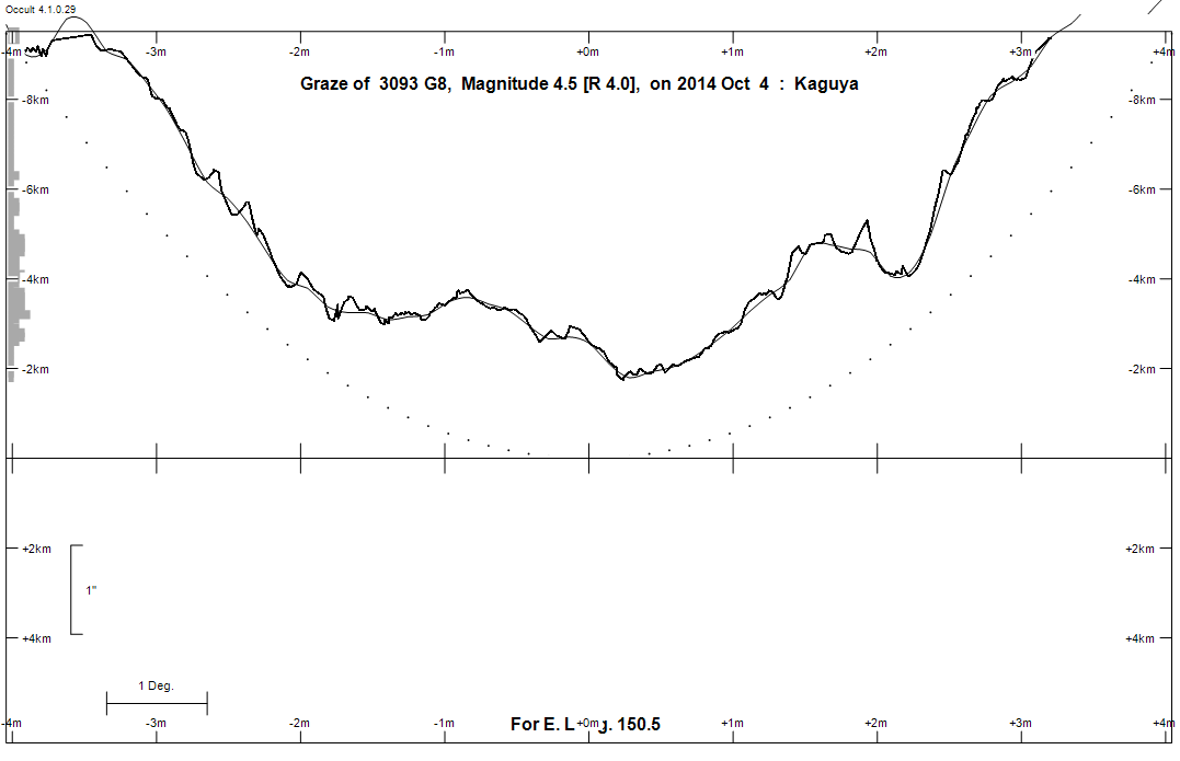
Grazing Occultation of    3093 G8      Magnitude 4.5 [Red = 4.0]
   R3093 = nu Aquarii
Date: 2014 Oct 04 11h 14m,  to  2014 Oct 04 12h  8m

Nominal site altitude 100m

E. Longit.   Latitude     U.T.    Sun  Moon   TanZ   PA    AA      CA
   o  '  "    o  '  "   h  m  s   Alt Alt Az          o     o      o
 133  0  0  -32 34 56  11 13 46       69   8  0.39 157.5 175.29   9.00S
 133 30  0  -32 23 58  11 14 53       69   6  0.38 157.3 175.18   9.11S
 134  0  0  -32 12 49  11 16  0       69   4  0.38 157.2 175.07   9.22S
 134 30  0  -32  1 29  11 17  8       69   2  0.37 157.1 174.96   9.33S
 135  0  0  -31 49 58  11 18 17       70 360  0.37 157.0 174.85   9.44S
 135 30  0  -31 38 16  11 19 26       70 358  0.37 156.9 174.74   9.55S
 136  0  0  -31 26 23  11 20 36       70 355  0.36 156.8 174.64   9.65S
 136 30  0  -31 14 20  11 21 46       70 353  0.36 156.7 174.54   9.75S
 137  0  0  -31  2  6  11 22 57       70 351  0.36 156.6 174.43   9.85S
 137 30  0  -30 49 41  11 24  8       70 348  0.36 156.5 174.33   9.95S
 138  0  0  -30 37  6  11 25 20       70 346  0.36 156.4 174.24  10.05S
 138 30  0  -30 24 20  11 26 32       70 343  0.36 156.3 174.14  10.15S
 139  0  0  -30 11 24  11 27 45       70 341  0.36 156.2 174.05  10.24S
 139 30  0  -29 58 18  11 28 58       70 339  0.36 156.1 173.96  10.33S
 140  0  0  -29 45  2  11 30 12       70 336  0.36 156.0 173.87  10.42S
 140 30  0  -29 31 37  11 31 26       70 334  0.36 155.9 173.78  10.50S
 141  0  0  -29 18  1  11 32 40       70 331  0.36 155.9 173.70  10.59S
 141 30  0  -29  4 16  11 33 55       70 329  0.37 155.8 173.62  10.67S
 142  0  0  -28 50 22  11 35 10       70 326  0.37 155.7 173.54  10.75S
 142 30  0  -28 36 19  11 36 25       69 324  0.37 155.6 173.46  10.82S
 143  0  0  -28 22  8  11 37 41       69 322  0.38 155.6 173.39  10.90S
 143 30  0  -28  7 47  11 38 57       69 320  0.38 155.5 173.32  10.97S
 144  0  0  -27 53 19  11 40 13       69 317  0.39 155.4 173.25  11.03S
 144 30  0  -27 38 42  11 41 30       68 315  0.40 155.3 173.18  11.11S
 145  0  0  -27 23 58  11 42 47       68 313  0.40 155.3 173.12  11.17S
 145 30  0  -27  9  6  11 44  3       68 311  0.41 155.2 173.06  11.22S
 146  0  0  -26 54  7  11 45 21       67 309  0.42 155.2 173.01  11.28S
 146 30  0  -26 39  1  11 46 38       67 307  0.43 155.1 172.95  11.33S
 147  0  0  -26 23 49  11 47 55       66 305  0.44 155.1 172.91  11.38S
 147 30  0  -26  8 31  11 49 12       66 304  0.45 155.0 172.86  11.42S
 148  0  0  -25 53  7  11 50 29       65 302  0.46 155.0 172.82  11.46S
 148 30  0  -25 37 38  11 51 47       65 300  0.47 155.0 172.79  11.50S
 149  0  0  -25 22  3  11 53  4       64 299  0.48 154.9 172.75  11.53S
 149 30  0  -25  6 24  11 54 21       64 297  0.49 154.9 172.72  11.56S
 150  0  0  -24 50 41  11 55 38       63 296  0.50 154.9 172.69  11.59S
 150 30  0  -24 34 54  11 56 55       63 294  0.52 154.8 172.67  11.62S
 151  0  0  -24 19  4  11 58 12       62 293  0.53 154.8 172.65  11.64S
 151 30  0  -24  3 10  11 59 28       62 292  0.54 154.8 172.63  11.65S
 152  0  0  -23 47 14  12  0 44       61 290  0.56 154.8 172.62  11.67S
 152 30  0  -23 31 16  12  2  0       60 289  0.57 154.8 172.61  11.68S
 153  0  0  -23 15 15  12  3 15       60 288  0.58 154.8 172.60  11.68S
 153 30  0  -22 59 14  12  4 30       59 287  0.60 154.8 172.60  11.69S
 154  0  0  -22 43 11  12  5 45       58 286  0.62 154.8 172.60  11.69S
 154 30  0  -22 27  8  12  6 59       58 285  0.63 154.8 172.60  11.68S
 155  0  0  -22 11  5  12  8 13       57 284  0.65 154.8 172.61  11.67S

Path coordinates are referred to WGS84 (as used by GPS), with the
nominal site altitude being referenced to Mean Sea Level. The path
is adjusted for the effects of refraction at low moon altitudes.

Projected diameter of star  4 meters  [CHARM/CADARS, 4 measures]


    C A S S I N I   R E G I O N   G R A Z E
                Librations  Long -2.27   Lat -6.40
                            P +173.46     D -6.37
      Illumination of moon  79%+
        Elongation of Moon  125
    Vertical Profile Scale  1.98 km/arcsec at mean distance of moon
   Horizontal Scale Factor  1.39 deg/min


At longitude 144.00:
Limiting Magnitudes for various telescope apertures (in cm)
      CA\Tdia   5    10    15    20    25    30    35
     7.0      5.0   6.5   7.3   7.8   8.1   8.4   8.6
     9.0      5.7   7.1   7.9   8.5   8.8   9.1   9.3
    11.0      5.7   7.1   8.0   8.5   8.9   9.1   9.3
    13.0      5.7   7.2   8.0   8.5   8.9   9.1   9.3
    15.0      5.7   7.2   8.0   8.5   8.9   9.2   9.4

------------------------------------------------------------------------------
Results of Observer Scan                                    UT
Site                              Long.   Lat.   Dist.    h  m  s
Albany                            117.8  -35.0   184km   10 44 37
Bundaberg                         152.3  -24.8   114km   12  1 35
Rockhampton                       150.5  -23.4   117km   11 56 55
Lunar Limb Profile - Gladstone.