Predictions for Grazing Occultation of SAO 159188, 2014 Sep 28, Melbourne
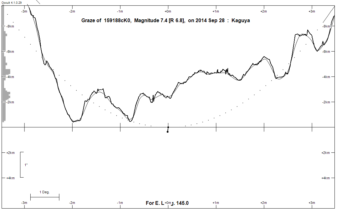
Graze profile Melbourne
Grazing Occultation of  159188cK0      Magnitude 7.4 [Red = 6.8]
Date: 2014 Sep 28  9h 19m,  to  2014 Sep 28  9h 39m

Nominal site altitude 100m

E. Longit.   Latitude     U.T.    Sun  Moon   TanZ   PA    AA      CA
   o  '  "    o  '  "   h  m  s   Alt Alt Az          o     o      o
 133  0  0  -39 39 33   9 19 14   -3  41 285  1.16 188.0 172.03   3.64S
 133 30  0  -39 36 43   9 19 50   -3  40 284  1.18 188.0 171.94   3.73S
 134  0  0  -39 33 46   9 20 26   -4  40 284  1.20 187.9 171.86   3.81S
 134 30  0  -39 30 43   9 21  2   -4  39 283  1.22 187.8 171.78   3.90S
 135  0  0  -39 27 34   9 21 37   -5  39 283  1.24 187.7 171.69   3.98S
 135 30  0  -39 24 18   9 22 11   -5  38 282  1.26 187.6 171.61   4.06S
 136  0  0  -39 20 55   9 22 46   -6  38 281  1.29 187.5 171.53   4.14S
 136 30  0  -39 17 27   9 23 19   -6  37 281  1.31 187.5 171.45   4.22S
 137  0  0  -39 13 52   9 23 53   -7  37 280  1.33 187.4 171.37   4.30S
 137 30  0  -39 10 11   9 24 26   -7  36 280  1.35 187.3 171.30   4.38S
 138  0  0  -39  6 24   9 24 58   -8  36 279  1.38 187.2 171.22   4.45S
 138 30  0  -39  2 31   9 25 30   -8  35 279  1.40 187.2 171.14   4.53S
 139  0  0  -38 58 32   9 26  2   -9  35 278  1.43 187.1 171.07   4.60S
 139 30  0  -38 54 26   9 26 33   -9  35 278  1.45 187.0 171.00   4.67S
 140  0  0  -38 50 15   9 27  4  -10  34 277  1.48 186.9 170.92   4.75S
 140 30  0  -38 45 59   9 27 35  -10  34 277  1.51 186.9 170.85   4.82S
 141  0  0  -38 41 36   9 28  5  -11  33 277  1.53 186.8 170.78   4.89S
 141 30  0  -38 37  8   9 28 35  -11  33 276  1.56 186.7 170.71   4.96S
 142  0  0  -38 32 34   9 29  4  -12  32 276  1.59 186.7 170.64   5.03S
 142 30  0  -38 27 55   9 29 33       32 275  1.62 186.6 170.58   5.09S
 143  0  0  -38 23 10   9 30  1       31 275  1.65 186.5 170.51   5.16S
 143 30  0  -38 18 20   9 30 29       31 274  1.68 186.5 170.44   5.22S
 144  0  0  -38 13 24   9 30 57       30 274  1.72 186.4 170.38   5.29S
 144 30  0  -38  8 23   9 31 24       30 273  1.75 186.3 170.32   5.35S
 145  0  0  -38  3 17   9 31 51       29 273  1.78 186.3 170.25   5.41S
 145 30  0  -37 58  6   9 32 17       29 272  1.82 186.2 170.19   5.48S
 146  0  0  -37 52 49   9 32 43       28 272  1.85 186.1 170.13   5.54S
 146 30  0  -37 47 28   9 33  8       28 272  1.89 186.1 170.07   5.60S
 147  0  0  -37 42  1   9 33 33       27 271  1.93 186.0 170.01   5.65S
 147 30  0  -37 36 30   9 33 58       27 271  1.97 186.0 169.96   5.71S
 148  0  0  -37 30 53   9 34 22       26 270  2.01 185.9 169.90   5.77S
 148 30  0  -37 25 12   9 34 46       26 270  2.05 185.9 169.84   5.82S
 149  0  0  -37 19 26   9 35  9       25 270  2.10 185.8 169.79   5.88S
 149 30  0  -37 13 36   9 35 32       25 269  2.14 185.7 169.74   5.93S
 150  0  0  -37  7 41   9 35 55       25 269  2.19 185.7 169.68   5.99S
 150 30  0  -37  1 41   9 36 17       24 268  2.24 185.6 169.63   6.04S
 151  0  0  -36 55 37   9 36 38       24 268  2.29 185.6 169.58   6.09S
 151 30  0  -36 49 29   9 36 59       23 268  2.34 185.5 169.53   6.14S
 152  0  0  -36 43 16   9 37 20       23 267  2.40 185.5 169.48   6.19S
 152 30  0  -36 36 59   9 37 40       22 267  2.46 185.4 169.43   6.24S
 153  0  0  -36 30 38   9 38  0       22 266  2.52 185.4 169.38   6.28S
 153 30  0  -36 24 13   9 38 20       21 266  2.58 185.3 169.34   6.33S
 154  0  0  -36 17 43   9 38 39       21 266  2.64 185.3 169.29   6.38S
 154 30  0  -36 11 10   9 38 57       20 265  2.71 185.3 169.25   6.42S
 155  0  0  -36  4 32   9 39 15       20 265  2.78 185.2 169.20   6.47S

Path coordinates are referred to WGS84 (as used by GPS), with the
nominal site altitude being referenced to Mean Sea Level. The path
is adjusted for the effects of refraction at low moon altitudes.

Projected diameter of star  2 meters  [Estimated]

159188 is double:
  AB 7.5 8.6 0.40" 124.0 (MCA  41) Graze path of B 0.37 km north, and 0.8 secs later compared to A

                Librations  Long -6.72   Lat -4.03
                            P +170.86     D -4.83
      Illumination of moon  16%+
        Elongation of Moon  47
    Vertical Profile Scale  2.00 km/arcsec at mean distance of moon
   Horizontal Scale Factor  1.66 deg/min


At longitude 144.00:
Limiting Magnitudes for various telescope apertures (in cm)
      CA\Tdia   5    10    15    20    25    30    35
     1.3      5.3   6.7   7.5   8.0   8.4   8.7   8.9
     3.3      5.3   6.8   7.6   8.1   8.5   8.7   8.9
     5.3      5.4   6.8   7.6   8.1   8.5   8.8   9.0
     7.3      5.4   6.9   7.7   8.2   8.5   8.8   9.0
     9.3      6.3   7.8   8.6   9.2   9.6   9.9  10.1

------------------------------------------------------------------------------
Double star catalogue details
WDS entries

  RA  Dec Name          Y1   Y2     N  PA  PA   Sep   Sep  M1    M2
15210-1522MCA  41      1980 1980    1 124 124   0.4   0.4  7.5   8.6  K0III     -018-012          -14 4182      152057.18-152225.4


------------------------------------------------------------------------------
Results of Observer Scan                                    UT
Site                              Long.   Lat.   Dist.    h  m  s
Lunar Limb Profile - Melbourne.