Predictions for Grazing Occultation of ZC 3093, 2014 Aug 10, Maryborough, Qld
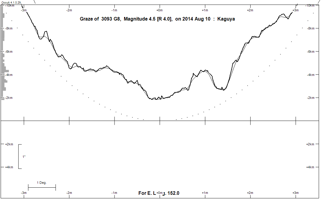
Graze profile Maryborough
Grazing Occultation of    3093 G8      Magnitude 4.5 [Red = 4.0]
   R3093 = nu Aquarii
Date: 2014 Aug 10 15h 59m,  to  2014 Aug 10 16h 46m

Nominal site altitude 100m

E. Longit.   Latitude     U.T.    Sun  Moon   TanZ   PA    AA      CA
   o  '  "    o  '  "   h  m  s   Alt Alt Az          o     o      o
 133  0  0  -35 37 29  15 58 38       63 329  0.52 156.5 174.29  81.08S
 133 30  0  -35 23 50  15 59 44       63 327  0.52 156.5 174.23  81.13S
 134  0  0  -35 10  4  16  0 50       62 325  0.52 156.4 174.16  81.18S
 134 30  0  -34 56  9  16  1 56       62 323  0.53 156.3 174.11  81.23S
 135  0  0  -34 42  6  16  3  2       62 322  0.53 156.3 174.05  81.28S
 135 30  0  -34 27 56  16  4  9       62 320  0.54 156.2 173.99  81.32S
 136  0  0  -34 13 38  16  5 16       62 319  0.54 156.2 173.94  81.37S
 136 30  0  -33 59 13  16  6 23       61 317  0.55 156.1 173.89  81.41S
 137  0  0  -33 44 42  16  7 31       61 315  0.55 156.1 173.84  81.44S
 137 30  0  -33 30  4  16  8 38       61 314  0.56 156.0 173.80  81.48S
 138  0  0  -33 15 19  16  9 46       60 312  0.57 156.0 173.75  81.51S
 138 30  0  -33  0 28  16 10 54       60 311  0.58 156.0 173.71  81.54S
 139  0  0  -32 45 32  16 12  1       60 309  0.58 155.9 173.67  81.57S
 139 30  0  -32 30 30  16 13  9       59 308  0.59 155.9 173.64  81.60S
 140  0  0  -32 15 23  16 14 17       59 306  0.60 155.8 173.61  81.62S
 140 30  0  -32  0 11  16 15 25       59 305  0.61 155.8 173.57  81.64S
 141  0  0  -31 44 54  16 16 33       58 304  0.62 155.8 173.55  81.66S
 141 30  0  -31 29 33  16 17 41       58 302  0.63 155.8 173.52  81.68S
 142  0  0  -31 14  8  16 18 49       57 301  0.64 155.7 173.50  81.69S
 142 30  0  -30 58 40  16 19 57       57 300  0.65 155.7 173.48  81.70S
 143  0  0  -30 43  9  16 21  4       56 298  0.66 155.7 173.46  81.71S
 143 30  0  -30 27 35  16 22 12       56 297  0.68 155.7 173.45  81.71S
 144  0  0  -30 11 58  16 23 19       55 296  0.69 155.7 173.44  81.72S
 144 30  0  -29 56 19  16 24 26       55 295  0.70 155.7 173.43  81.72S
 145  0  0  -29 40 38  16 25 33       54 294  0.72 155.7 173.42  81.71S
 145 30  0  -29 24 56  16 26 39       54 293  0.73 155.7 173.42  81.71S
 146  0  0  -29  9 13  16 27 45       53 292  0.74 155.7 173.42  81.70S
 146 30  0  -28 53 30  16 28 51       53 291  0.76 155.7 173.42  81.69S
 147  0  0  -28 37 46  16 29 56       52 290  0.77 155.7 173.43  81.68S
 147 30  0  -28 22  2  16 31  2       52 289  0.79 155.7 173.44  81.66S
 148  0  0  -28  6 18  16 32  6       51 288  0.81 155.7 173.45  81.65S
 148 30  0  -27 50 36  16 33 10       51 287  0.82 155.7 173.46  81.63S
 149  0  0  -27 34 54  16 34 14       50 286  0.84 155.7 173.47  81.61S
 149 30  0  -27 19 15  16 35 17       49 285  0.86 155.7 173.49  81.58S
 150  0  0  -27  3 36  16 36 20       49 284  0.87 155.8 173.51  81.55S
 150 30  0  -26 48  1  16 37 22       48 283  0.89 155.8 173.54  81.53S
 151  0  0  -26 32 27  16 38 24       48 283  0.91 155.8 173.56  81.49S
 151 30  0  -26 16 57  16 39 25       47 282  0.93 155.8 173.59  81.46S
 152  0  0  -26  1 29  16 40 25       46 281  0.95 155.9 173.62  81.43S
 152 30  0  -25 46  6  16 41 24       46 280  0.97 155.9 173.65  81.39S
 153  0  0  -25 30 46  16 42 23       45 280  0.99 155.9 173.69  81.35S
 153 30  0  -25 15 30  16 43 22       45 279  1.02 156.0 173.72  81.31S
 154  0  0  -25  0 18  16 44 19       44 278  1.04 156.0 173.76  81.26S
 154 30  0  -24 45 11  16 45 16       43 278  1.06 156.0 173.80  81.22S
 155  0  0  -24 30  9  16 46 12       43 277  1.08 156.1 173.84  81.17S

Path coordinates are referred to WGS84 (as used by GPS), with the
nominal site altitude being referenced to Mean Sea Level. The path
is adjusted for the effects of refraction at low moon altitudes.

Projected diameter of star  4 meters  [CHARM/CADARS, 4 measures]


    C A S S I N I   R E G I O N   G R A Z E
                Librations  Long -0.16   Lat -6.44
                            P +173.42     D -6.16
      Illumination of moon  100%+
        Elongation of Moon  175
    Vertical Profile Scale  2.09 km/arcsec at mean distance of moon
   Horizontal Scale Factor  1.57 deg/min


At longitude 144.00:
Limiting Magnitudes for various telescope apertures (in cm)
      CA\Tdia   5    10    15    20    25    30    35
    77.7      4.4   5.8   6.6   7.1   7.5   7.7   7.9
    79.7      4.4   5.8   6.6   7.1   7.5   7.7   7.9
    81.7      4.4   5.8   6.6   7.1   7.5   7.7   7.9
    83.7      4.4   5.8   6.6   7.1   7.5   7.7   7.9
    85.7      4.4   5.8   6.6   7.1   7.5   7.7   7.9

------------------------------------------------------------------------------
Results of Observer Scan                                    UT
Site                              Long.   Lat.   Dist.    h  m  s
Adelaide                          138.6  -34.9   186km   16 11  7
Brisbane                          153.1  -27.5   191km   16 42 29
Bundaberg                         152.3  -24.8   102km   16 41  5
Lunar Limb Profile - Maryborough.