Predictions for Grazing Occultation of ZC 1518, 2014 Jul 2, Newcastle NSW.
Graze profile Newcastle
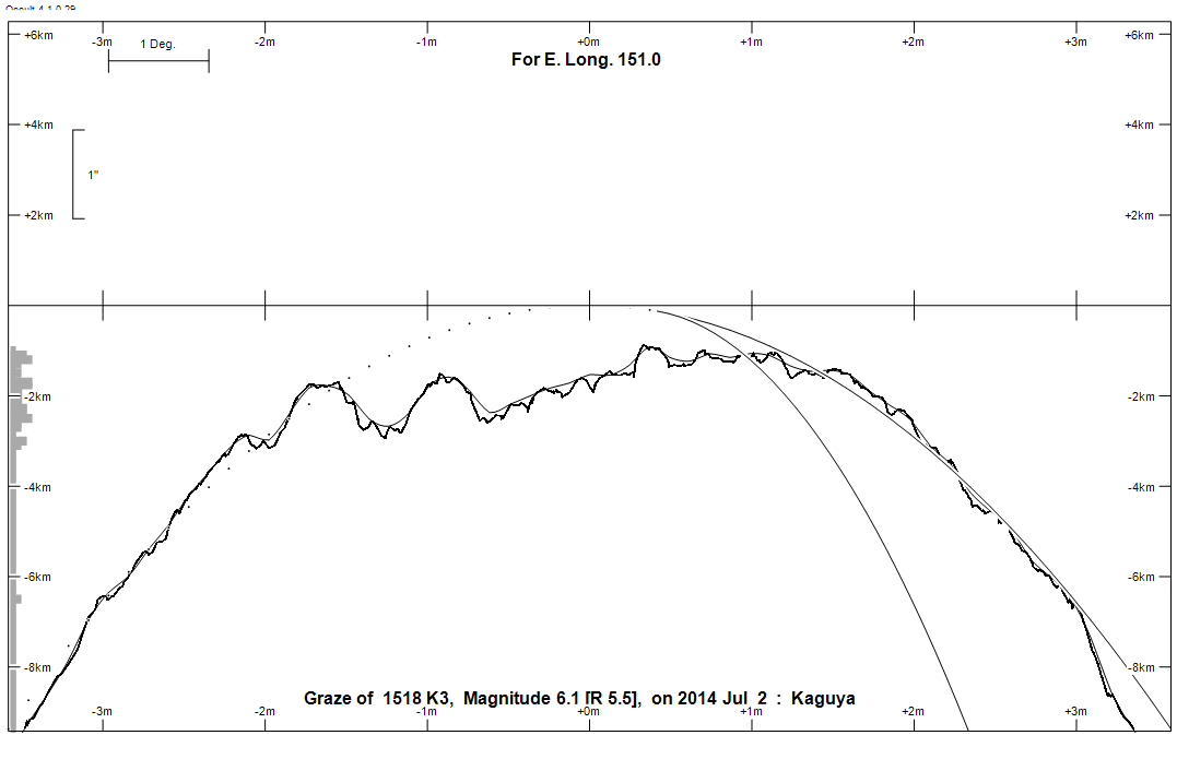
Grazing Occultation of    1518 K3      Magnitude 6.1 [Red = 5.5]
   R1518 = 43 Leonis
Date: 2014 Jul 02  9h 28m,  to  2014 Jul 02  9h 54m

Nominal site altitude 100m

E. Longit.   Latitude     U.T.    Sun  Moon   TanZ   PA    AA      CA
   o  '  "    o  '  "   h  m  s   Alt Alt Az          o     o      o
 133  0  0  -26 36 41   9 28 22       40 305  1.21  28.8   6.50   5.01N
 133 30  0  -26 49 53   9 29 20       39 304  1.24  28.7   6.36   4.87N
 134  0  0  -27  2 53   9 30 16       38 304  1.27  28.6   6.22   4.74N
 134 30  0  -27 15 42   9 31 11       38 304  1.30  28.4   6.09   4.61N
 135  0  0  -27 28 19   9 32  5       37 303  1.33  28.3   5.96   4.48N
 135 30  0  -27 40 45   9 32 58       36 303  1.37  28.2   5.83   4.34N
 136  0  0  -27 53  0   9 33 49       36 302  1.40  28.0   5.70   4.21N
 136 30  0  -28  5  4   9 34 39       35 302  1.43  27.9   5.57   4.08N
 137  0  0  -28 16 57   9 35 28       34 301  1.47  27.8   5.44   3.95N
 137 30  0  -28 28 39   9 36 16       34 301  1.50  27.6   5.31   3.82N
 138  0  0  -28 40 10   9 37  3       33 300  1.54  27.5   5.18   3.70N
 138 30  0  -28 51 31   9 37 49       32 300  1.57  27.4   5.05   3.57N
 139  0  0  -29  2 41   9 38 33       32 300  1.61  27.3   4.92   3.44N
 139 30  0  -29 13 41   9 39 17       31 299  1.65  27.1   4.80   3.32N
 140  0  0  -29 24 31   9 39 59       31 299  1.69  27.0   4.67   3.19N
 140 30  0  -29 35 11   9 40 41       30 298  1.73  26.9   4.55   3.07N
 141  0  0  -29 45 41   9 41 21       29 298  1.78  26.8   4.43   2.95N
 141 30  0  -29 56  1   9 42  0       29 298  1.82  26.6   4.31   2.83N
 142  0  0  -30  6 11   9 42 39       28 297  1.86  26.5   4.19   2.71N
 142 30  0  -30 16 12   9 43 16       28 297  1.91  26.4   4.07   2.58N
 143  0  0  -30 26  3   9 43 53       27 296  1.96  26.3   3.95   2.46N
 143 30  0  -30 35 45   9 44 28       26 296  2.01  26.2   3.83   2.34N
 144  0  0  -30 45 18   9 45  3       26 296  2.06  26.0   3.71   2.23N
 144 30  0  -30 54 41   9 45 37       25 295  2.11  25.9   3.59   2.11N
 145  0  0  -31  3 56   9 46  9       25 295  2.17  25.8   3.48   1.99N
 145 30  0  -31 13  1   9 46 41       24 295  2.22  25.7   3.36   1.88N
 146  0  0  -31 21 58   9 47 13       24 294  2.28  25.6   3.25   1.76N
 146 30  0  -31 30 47   9 47 43       23 294  2.34  25.5   3.13   1.65N
 147  0  0  -31 39 26   9 48 12       23 293  2.40  25.4   3.02   1.54N
 147 30  0  -31 47 58   9 48 41       22 293  2.47  25.2   2.91   1.43N
 148  0  0  -31 56 21   9 49  9       22 293  2.54  25.1   2.80   1.32N
 148 30  0  -32  4 35   9 49 36       21 292  2.61  25.0   2.69   1.21N
 149  0  0  -32 12 42   9 50  2       20 292  2.68  24.9   2.58   1.10N
 149 30  0  -32 20 41   9 50 28       20 292  2.76  24.8   2.47   0.99N
 150  0  0  -32 28 31   9 50 53       19 291  2.84  24.7   2.37   0.88N
 150 30  0  -32 36 14   9 51 17       19 291  2.93  24.6   2.26   0.78N
 151  0  0  -32 43 49   9 51 40       18 291  3.01  24.5   2.16   0.67N
 151 30  0  -32 51 17   9 52  3       18 290  3.11  24.4   2.05   0.57N
 152  0  0  -32 58 37   9 52 25       17 290  3.20  24.3   1.95   0.47N
 152 30  0  -33  5 49   9 52 46       17 290  3.31  24.2   1.85   0.37N
 153  0  0  -33 12 54   9 53  7       16 289  3.41  24.1   1.75   0.27N
 153 30  0  -33 19 52   9 53 27       16 289  3.53  24.0   1.65   0.17N
 154  0  0  -33 26 43   9 53 46       15 289  3.65  23.9   1.56   0.08N
 154 30  0  -33 33 26   9 54  5       15 288  3.78  23.8   1.46  -0.02N
 155  0  0  -33 40  3   9 54 23       14 288  3.91  23.7   1.37  -0.12N

Path coordinates are referred to WGS84 (as used by GPS), with the
nominal site altitude being referenced to Mean Sea Level. The path
is adjusted for the effects of refraction at low moon altitudes.

Projected diameter of star  2 meters  [Estimated]


    C A S S I N I   R E G I O N   G R A Z E
                Librations  Long -3.88   Lat +4.72
                            P +3.41     D -4.70
      Illumination of moon  21%+
        Elongation of Moon  55
    Vertical Profile Scale  1.96 km/arcsec at mean distance of moon
   Horizontal Scale Factor  1.52 deg/min


At longitude 144.00:
Limiting Magnitudes for various telescope apertures (in cm)
      CA\Tdia   5    10    15    20    25    30    35
    -1.8      3.3   4.7   5.4   5.8   6.0   6.2   6.3
     0.2      5.0   6.4   7.2   7.7   8.0   8.3   8.5
     2.2      5.0   6.5   7.2   7.7   8.1   8.3   8.5
     4.2      5.0   6.5   7.2   7.7   8.1   8.3   8.5
     6.2      5.1   6.5   7.3   7.8   8.1   8.4   8.6

------------------------------------------------------------------------------
Results of Observer Scan                                    UT
Site                              Long.   Lat.   Dist.    h  m  s
Newcastle                         151.7  -33.0     4km    9 52 12
Pt Macquarie                      152.8  -31.4   190km    9 53  0
Sydney                            151.1  -33.8   116km    9 51 43
Lunar Limb Profile - Newcastle