Predictions for Grazing Occultation of ZC 1428, 2014 Jan 18
Graze profile
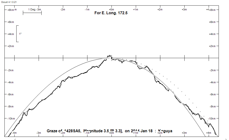
Grazing Occultation of    1428SA5      Magnitude 3.5 [Red = 3.3]
   R1428 = omicron Leonis
Date: 2014 Jan 18 14h 38m,  to  2014 Jan 18 15h  3m

Nominal site altitude 100m

E. Longit.   Latitude     U.T.    Sun  Moon   TanZ   PA    AA      CA
   o  '  "    o  '  "   h  m  s   Alt Alt Az          o     o      o
 167  0  0  -40  7 31  14 38 10       40   1  1.18  26.8   7.05   0.53N
 167 30  0  -40 25 38  14 39 24       40   0  1.19  26.8   7.06   0.52N
 168  0  0  -40 43 43  14 40 37       40 359  1.21  26.8   7.06   0.51N
 168 30  0  -41  1 48  14 41 50       39 358  1.22  26.8   7.06   0.51N
 169  0  0  -41 19 52  14 43  1       39 357  1.24  26.8   7.05   0.52N
 169 30  0  -41 37 53  14 44 11       39 356  1.25  26.8   7.05   0.53N
 170  0  0  -41 55 52  14 45 21       38 355  1.27  26.8   7.03   0.54N
 170 30  0  -42 13 47  14 46 29       38 354  1.28  26.7   7.02   0.56N
 171  0  0  -42 31 40  14 47 37       38 353  1.30  26.7   7.00   0.58N
 171 30  0  -42 49 28  14 48 43       37 352  1.32  26.7   6.97   0.60N
 172  0  0  -43  7 12  14 49 49       37 351  1.33  26.7   6.95   0.63N
 172 30  0  -43 24 51  14 50 53       36 351  1.35  26.6   6.92   0.66N
 173  0  0  -43 42 25  14 51 56       36 350  1.37  26.6   6.89   0.69N
 173 30  0  -43 59 53  14 52 58       36 349  1.39  26.6   6.85   0.72N
 174  0  0  -44 17 16  14 54  0       35 348  1.41  26.5   6.82   0.76N
 174 30  0  -44 34 33  14 55  0       35 347  1.43  26.5   6.78   0.80N
 175  0  0  -44 51 43  14 55 59       35 346  1.45  26.5   6.74   0.84N
 175 30  0  -45  8 47  14 56 57       34 345  1.48  26.4   6.69   0.89N
 176  0  0  -45 25 44  14 57 53       34 345  1.50  26.4   6.65   0.93N
 176 30  0  -45 42 33  14 58 49       33 344  1.52  26.3   6.60   0.98N
 177  0  0  -45 59 16  14 59 44       33 343  1.55  26.3   6.55   1.03N
 177 30  0  -46 15 50  15  0 37       32 342  1.57  26.2   6.50   1.08N
 178  0  0  -46 32 18  15  1 30       32 341  1.60  26.2   6.45   1.13N
 178 30  0  -46 48 37  15  2 21       32 341  1.62  26.1   6.39   1.19N
 179  0  0  -47  4 48  15  3 12       31 340  1.65  26.1   6.34   1.24N

Path coordinates are referred to WGS84 (as used by GPS), with the
nominal site altitude being referenced to Mean Sea Level.

Projected diameter of star  3 meters  [CHARM/CADARS, 4 measures]

1428 is quadruple:
  Aa,Ab 3.5      0.004" 192.3 (HMM   1) Graze path of Ab 0.01 km north, and 0.0 secs later compared to Aa
  Aa,Ac 3.5      0.60" 268.0 (ARI   1) Graze path of Ac 0.74 km north, and 1.5 secs earlier compared to Aa
  AB 3.6 10.8 97"  47.1 (H 6  76) Graze path of B 235.32 km south, and 100.0 secs later compared to A

    C A S S I N I   R E G I O N   G R A Z E
                Librations  Long -3.51   Lat +5.43
                            P +6.59     D -5.56
      Illumination of moon  95%-
        Elongation of Moon  154
    Vertical Profile Scale  2.72 km/arcsec at mean distance of moon
   Horizontal Scale Factor  1.32 deg/min


At longitude 173.00:
Limiting Magnitudes for various telescope apertures (in cm)
      CA\Tdia   5    10    15    20    25    30    35
    -3.3      2.3   3.7   4.4   4.9   5.2   5.4   5.5
    -1.3      2.3   3.7   4.4   4.9   5.2   5.4   5.5
     0.7      2.3   3.7   4.4   4.9   5.2   5.4   5.5
     2.7      2.3   3.7   4.4   4.9   5.2   5.4   5.5
     4.7      2.3   3.7   4.4   4.9   5.2   5.4   5.5

------------------------------------------------------------------------------
Double star catalogue details
WDS entries

  RA  Dec Name          Y1   Y2     N  PA  PA   Sep   Sep  M1    M2
09412+0954HMM   1Aa,Ab 1990 2010   25  90 355   0.0   0.0  3.52       A5V  F6II -142-037          +10 2044 NO   094109.12+095332.6
09412+0954ARI   1Aa,Ac 1997 1997    1 268 268   0.6   0.6  3.52       A5V  F6II -142-037          +10 2044 NX   094109.12+095332.6
09412+0954H 6  76AB    1783 2011   26  40  47  63.5  96.8  3.56 10.83           -142-038 -008-005          NL   094109.12+095332.6

------------------------------------------------

------------------------------------------------------------------------------
Results of Observer Scan                                    UT
Site                              Long.   Lat.   Dist.    h  m  s
Chch graze                        172.6  -43.5     3km   14 51 10
Dunedin                           170.5  -45.9   308km   14 46 29
MidNZ                             173.0  -41.0   238km   14 51 56
Wellington                        174.8  -41.3   305km   14 55 35
Lunar Limb Profile