Predictions for Grazing Occultation of ZC 2118, 2013 Feb 3
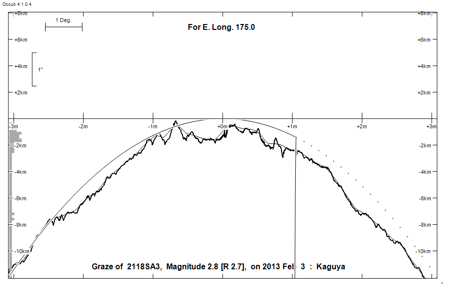
Graze profile
Grazing Occultation of    2118SA3      Magnitude 2.8 [Red = 2.7]  s
   R2118 = Zubenelgenubi = alpha Librae
Date: 2013 Feb 03 13h 38m,  to  2013 Feb 03 13h 44m

Nominal site altitude 100m

E. Longit.   Latitude     U.T.    Sun  Moon   TanZ   PA    AA      CA
   o  '  "    o  '  "   h  m  s   Alt Alt Az          o     o      o
 174  0  0  -39 22  0  13 38  8       25  91  2.14  18.9   0.44  -1.94N
 174 10  0  -39 26 54  13 38 19       25  91  2.12  18.9   0.45  -1.95N
 174 20  0  -39 31 48  13 38 30       25  90  2.11  18.9   0.46  -1.96N
 174 30  0  -39 36 42  13 38 42       26  90  2.09  18.9   0.46  -1.96N
 174 40  0  -39 41 37  13 38 53       26  90  2.08  18.9   0.47  -1.97N
 174 50  1  -39 46 33  13 39  4       26  90  2.06  18.9   0.48  -1.98N
 175  0  1  -39 51 29  13 39 16       26  90  2.05  19.0   0.49  -1.99N
 175 10  1  -39 56 26  13 39 27       26  90  2.03  19.0   0.49  -1.99N
 175 20  1  -40  1 23  13 39 39       26  89  2.02  19.0   0.50  -2.00N
 175 30  1  -40  6 20  13 39 50       27  89  2.00  19.0   0.51  -2.01N
 175 40  1  -40 11 18  13 40  2       27  89  1.99  19.0   0.52  -2.02N
 175 50  1  -40 16 16  13 40 14       27  89  1.97  19.0   0.52  -2.02N
 176  0  1  -40 21 15  13 40 26       27  89  1.96  19.0   0.53  -2.03N
 176 10  2  -40 26 14  13 40 38       27  88  1.95  19.0   0.54  -2.04N
 176 20  2  -40 31 14  13 40 50       27  88  1.93  19.0   0.54  -2.04N
 176 30  2  -40 36 14  13 41  2       28  88  1.92  19.0   0.55  -2.05N
 176 40  2  -40 41 14  13 41 14       28  88  1.91  19.0   0.56  -2.06N
 176 50  2  -40 46 15  13 41 26       28  88  1.89  19.0   0.56  -2.06N
 177  0  2  -40 51 16  13 41 39       28  88  1.88  19.0   0.57  -2.07N
 177 10  2  -40 56 18  13 41 51       28  87  1.87  19.0   0.57  -2.07N
 177 20  2  -41  1 20  13 42  3       28  87  1.85  19.0   0.58  -2.08N
 177 30  3  -41  6 22  13 42 16       28  87  1.84  19.1   0.59  -2.09N
 177 40  3  -41 11 25  13 42 29       29  87  1.83  19.1   0.59  -2.09N
 177 50  3  -41 16 28  13 42 41       29  87  1.82  19.1   0.60  -2.10N
 178  0  3  -41 21 32  13 42 54       29  86  1.81  19.1   0.60  -2.10N
 178 10  3  -41 26 35  13 43  7       29  86  1.79  19.1   0.61  -2.11N
 178 20  3  -41 31 39  13 43 20       29  86  1.78  19.1   0.61  -2.11N
 178 30  3  -41 36 44  13 43 33       29  86  1.77  19.1   0.62  -2.12N
 178 40  3  -41 41 48  13 43 46       30  86  1.76  19.1   0.62  -2.12N
 178 50  3  -41 46 53  13 43 59       30  85  1.75  19.1   0.62  -2.12N

Path coordinates are referred to WGS84 (as used by GPS), with the
nominal site altitude being referenced to Mean Sea Level.

Projected diameter of star  3 meters  [CHARM/CADARS, 2 measures]

2118 is variable:
      2118 = NSV 6827, 2.72 to 2.75, V

2118 is quadruple:
  AB 2.7 5.2 231" 315.1 (SHJ 186) Graze path of B 263.57 km south, and 397.9 secs earlier compared to A
  AC 2.7 13.2 274" 291.0 (AOT  53) Graze path of C 24.60 km south, and 523.7 secs earlier compared to A
  AD 2.7 7.3 1000" 266.0 (SHY  75) Graze path of D 1014.55 km north, and 1762.5 secs earlier compared to A

                Librations  Long -3.51   Lat +0.11
                            P +0.56     D +0.12
      Illumination of moon  50%-
        Elongation of Moon  90
    Vertical Profile Scale  2.52 km/arcsec at mean distance of moon
   Horizontal Scale Factor  1.87 deg/min


At longitude 176.50:
Limiting Magnitudes for various telescope apertures (in cm)
      CA\Tdia   5    10    15    20    25    30    35
    -6.1      3.0   4.4   5.1   5.5   5.7   5.9   6.0
    -4.1      3.0   4.4   5.1   5.5   5.7   5.9   6.0
    -2.1      3.0   4.4   5.1   5.5   5.7   5.9   6.0
    -0.1      3.0   4.4   5.1   5.5   5.7   5.9   6.0
     1.9      4.8   6.2   6.9   7.4   7.7   7.9   8.0

------------------------------------------------------------------------------
Double star catalogue details
WDS entries

  RA  Dec Name          Y1   Y2     N  PA  PA   Sep   Sep  M1    M2
14509-1603SHJ 186AB    1836 2002   30 314 315 229.0 231.1  2.74  5.19 A3IV F4IV -106-068          -15 3966 NZD  145052.78-160229.8
14509-1603AOT  53AC    1987 1998    2 291 291 277.9 276.1  2.74 13.2  A3IV      -106-068                   N D  145052.78-160229.8
14509-1603CAB   1AD    1991 1999    3 266 266 999.9 999.9  2.74  7.31 A3IV G6V  -106-068 -116-065          NVD  145052.78-160229.8

------------------------------------------------
Interferometric catalogue entries

145052.78-160229.8  alp 2 Lib                 SHJ 186A                  HD 130841    HIP  72622         14509-1603
    Date       PA              Sep                  M1             M2
  1979.537       .      .   <  0.030      .          .      .       .      .       470       3.8   1  Hrt1984  Sc
  1980.485       .      .   <  0.025      .          .      .       .      .       400       3.8   1  Hrt1984  Sc

145052.78-160229.8  BDS  7018                 SHJ 186AB                 HD 130841    HIP  72622         14509-1603 N
    Date       PA              Sep                  M1             M2
  1991.25     314.0     .    230.738      .         2.75    .      5.15    .       550       0.3   1  HIP1997b Hh
  1991.75     314.0     .    230.77       .         2.742  0.009   5.194  0.009    530 100   1.4   1  TYC2002  Ht
  1991.75        .      .       .         .         2.930  0.014   5.609  0.014    430  90   1.4   1  TYC2002  Ht

145052.78-160229.8  BDS  7018                 SHY  75AD                 HD 130841    HIP  72622         14509-1603 N
    Date       PA              Sep                  M1             M2
  1991.25     266.1     .   M149.625      .         2.75    .      7.24    .       550       0.3   1  HIP1997a Hh
  1991.66     266.1     .   M149.625      .         2.742  0.009   7.313  0.012    530 100   1.4   1  TYC2002  Ht
  1991.66        .      .       .         .         2.930  0.014   8.142  0.017    430  90   1.4   1  TYC2002  Ht
  1999.36     266.2     .   M149.728      .         2.467  0.276   5.947  0.021   1256 245   1.3   1  TMA2003  E2
  1999.36        .      .       .         .         2.439  0.184   5.629  0.018   1633 160   1.3   1  TMA2003  E2
  1999.36        .      .       .         .         2.440  0.280   5.531  0.018   2210 200   1.3   1  TMA2003  E2


------------------------------------------------
AAVSO Variable star entry

       Variable identifier           Type        Max    Min  Ph  Epoch         Period
       NSV 6827                                  2.72   2.75 V
------------------------------------------------------------------------------
Results of Observer Scan                                    UT
Site                              Long.   Lat.   Dist.    h  m  s
Auckland                          174.8  -36.9   270km   13 39  2
Chch graze                        172.6  -43.5   446km   13 36 41
MidNZ                             173.0  -41.0   198km   13 37  4
Wellington                        174.8  -41.3   143km   13 39  2
Lunar Limb Profile