![]()
|
|
GRAZING OCCULTATION OF ZC 2796 - 2006 October 28
A grazing occultation of the magnitude 6.8 star ZC 2796 will be visible from Auckland City about 9.30 pm on the evening of Saturday October 28. In a grazing occultation the star just appears the "graze" along the edge of the Moon, alternately disappearing behind mountains on the edge of the moon, and then reappearing in the lunar valleys. These phenomena are usually visible from a band a few kilometres wide (but thousands of kilometres long) on the Earth. Rarely, such a graze band passes across a large city, and this will be the case on October 28.
As the star disappears and reappears during the graze the times of each event can be recorded using only simple equipment. Timings accurate to 0.1-0.2 seconds are quite feasible using a stopwatch or other simple method. By videoing the graze against a very accurate timebase, timings can be made to within 20 milliseconds - giving an accuracy in the moon's position of about 16 metres at the distance of the moon (384,400,000 metres).
Finding the star:
The diagram below shows the position and path of the star relative to the moon as would be seen by the naked eye. (In a telescope the view may appear inverted or back-to-front).
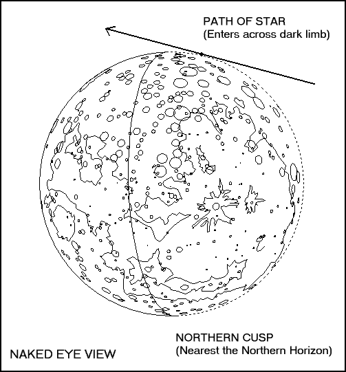
At central graze the star will be 14.5 degrees from the lighted southern cusp in the direction of the dark limb.
The Path:
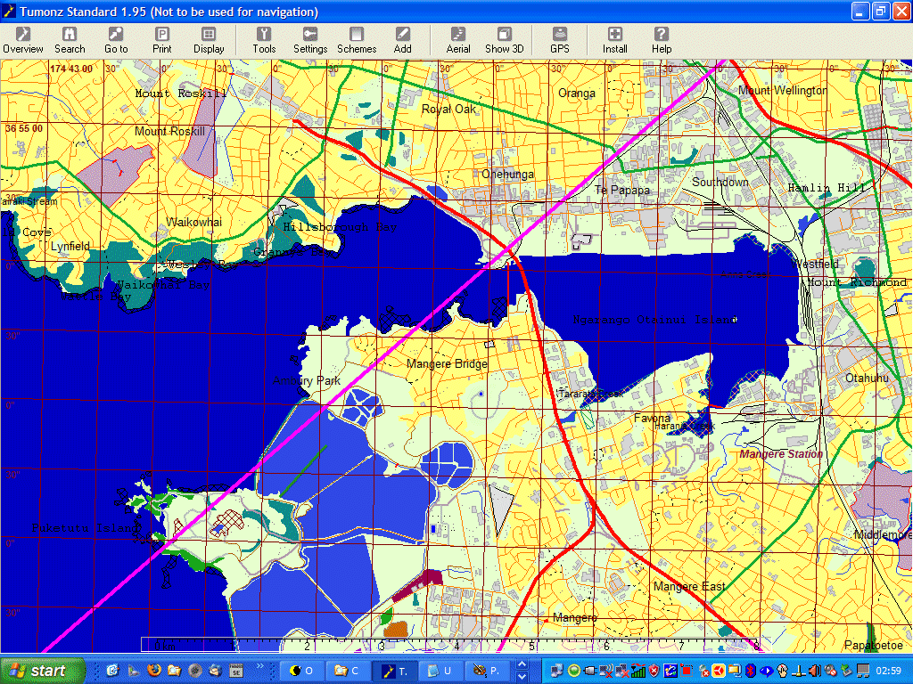
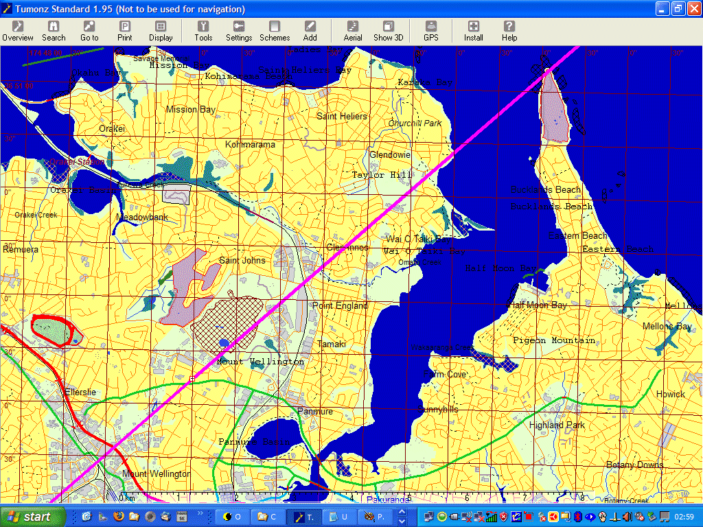
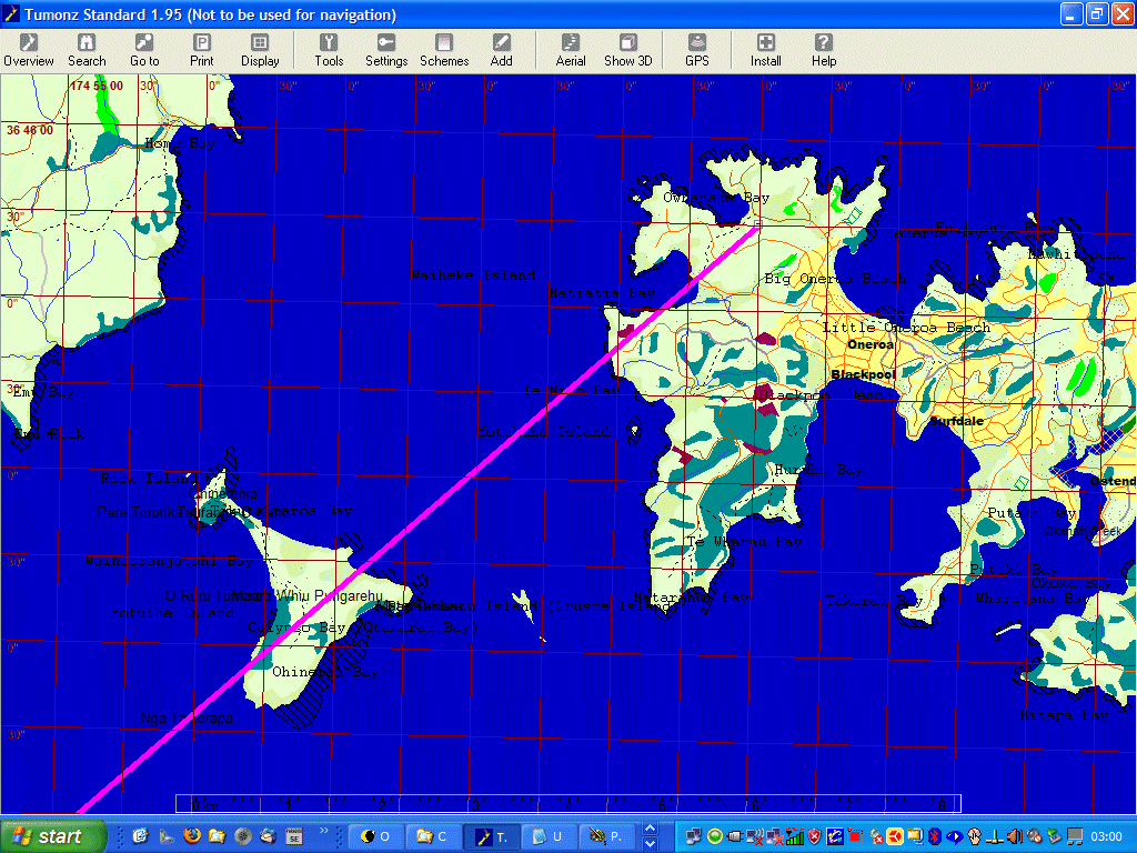
The path of the graze across Auckland is about 6 km wide and passes close to the Manukau Heads before bisecting Auckland from Mangere to Waiheke Island:
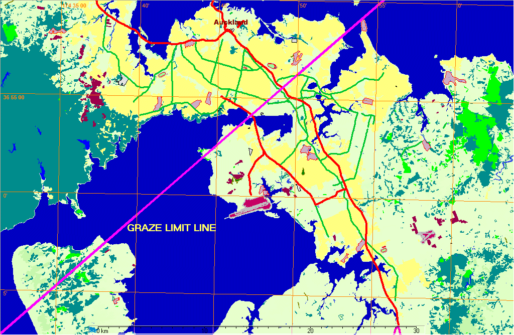
More details of the exact path are available below.
Graze Profile:
The profile of the edge of the moon below (drawn with north uppermost, so that the profile appears inverted) shows the expected shape of the Moon's southern limb near the point of occultation. The profile was prepared from charts prepared by Dr C.B. Watts of the U.S. Naval Observatory in the 1950s. The predicted profile is generally approximately correct, but frequently observations show up differences compared to what is expected. This is in fact the whole point of observing grazing occultations.
The zero km line drawn across the profile is called the "limit line". It represents the path the star would follow if it were to graze along the edge of a perfectly smooth Moon. An observer watching the star from somewhere near the limit line will see it enter the diagram from the left and follow a path which is defined by how far north or south of the limit line the observer is. Along the limit line are plotted minutes of time, measured from about three minutes before to three minutes after the time of central graze. By knowing where an observer is relative to the limit line, it is easy to get an idea of what events will be seen and when.
For example: An observer situated just under 2 km north of the limit line can expect to see the star disappear and reappear several times before being occulted for about 1.5 minutes. When the star reappears it may undergo a further series of occultations before moving away from the Moon.
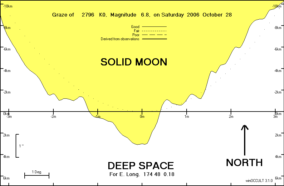
The time of central graze for Auckland city is about 9:32:29 pm (or 09:32:29 UT), and from the profile it will be seen that anyone from almost 4 km south to perhaps 2 km north of the limit line can expect to see the star occulted.
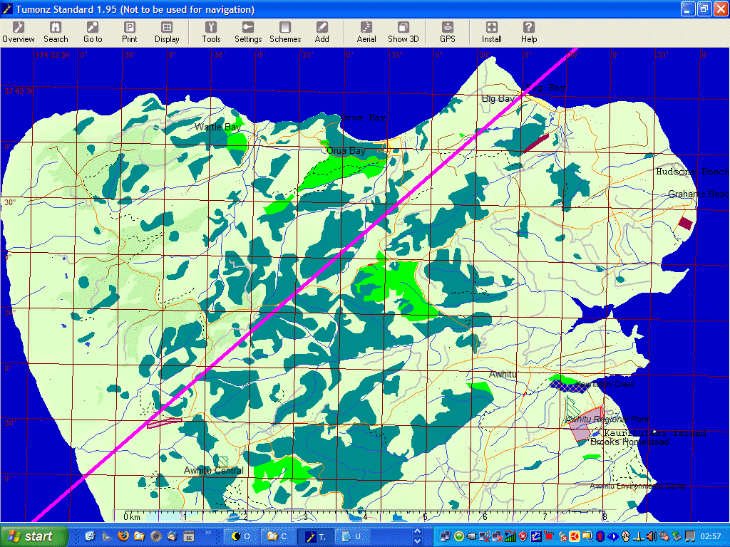
The Path - Details:
The path cust a swathe through the middle of Auckland, with the Auckland Observatory almost exactly 2.5 km north of the limit line. More detailed maps of the graze regions are available here:
For more information about how to observe this graze visit this page.
To participate in this graze please contact Helen McRae or phone her on 09-624-1815.
Path Co-ordinates:
Grazing Occultation of    2796  K0      Magnitude   6.8
Date   2006 October 28    (Saturday)     Nominal site altitude  0m

E. Longit.   Latitude     U.T.    Sun  Moon   TanZ   PA    WA      CA
   o  '  "    o  '  "   h  m  s   Alt Alt Az          o     o      o
 174  0  0  -37 30  5   9 31 13       34 260  1.46 160.2 166.67  14.49S
 174 10  0  -37 22 50   9 31 28       34 260  1.47 160.2 166.66  14.50S
 174 20  0  -37 15 34   9 31 44       34 260  1.48 160.2 166.65  14.51S
 174 30  0  -37  8 19   9 31 59       34 260  1.49 160.1 166.65  14.51S
 174 40  0  -37  1  3   9 32 14       34 259  1.51 160.1 166.64  14.52S
 174 50  0  -36 53 46   9 32 29       33 259  1.52 160.1 166.63  14.53S
 175  0  0  -36 46 30   9 32 44       33 259  1.53 160.1 166.63  14.53S
 175 10  0  -36 39 13   9 32 59       33 259  1.54 160.1 166.62  14.54S
 175 20  0  -36 31 56   9 33 14       33 259  1.55 160.1 166.62  14.54S
 175 30  0  -36 24 39   9 33 29       33 258  1.56 160.1 166.61  14.55S
 175 40  0  -36 17 21   9 33 44       32 258  1.58 160.1 166.61  14.55S
 175 50  0  -36 10  4   9 33 59       32 258  1.59 160.1 166.60  14.56S

Path coordinates are referred to WGS84 (as used by GPS).

                Librations  Long -6.97   Lat +5.77
                            P +165.9     D +4.3
      Illumination of moon  34%+
        Elongation of Moon  71
    Vertical Profile Scale  2.16 km/arcsec at mean distance of moon
   Horizontal Scale Factor  1.83 deg/min

Limiting Magnitudes for various telescope apertures (in mm)
      CA\Tdia  50   100   150   200   250   300   350
    10.6      5.8   7.3   8.1   8.6   9.0   9.3   9.5
    12.6      5.8   7.3   8.1   8.6   9.0   9.3   9.5
    14.6      5.8   7.3   8.1   8.6   9.0   9.3   9.5
    16.6      5.9   7.3   8.1   8.7   9.0   9.3   9.5
    18.6      5.9   7.3   8.1   8.7   9.0   9.3   9.5