![]()
|
|
|
GRAZING OCCULTATION OF ZC3431 on August 11, 2006 |
|---|
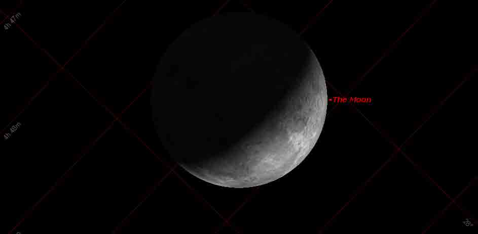
A grazing occultation of magnitude 6.6 ZC 3431 occurs at about 15:15 UT on Friday August 11 (about 3.15 am NZST on the morning of Saturday August 12). This occultation will be a difficult one since telescopes of eight inches aperture and above are likely to be required. Also the profile of the lunar limb at the point of the graze is not particularly spectacular. However the graze does run the length of the country which means that many observers throughout New Zealand may have the opportuity to observe it.
Graze Path:
| Wellington: |
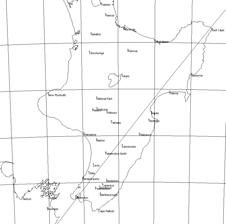 |
The graze "limit line" (line at which the star would just graze along the moon's limb if it were completely smooth) passes through Seatoun, and then through Gracefield, the eastern Hutt hills, Stokes Valley, Silverstream, Heretaunga and Trentham. Then through Woodville and west of Napier and Gisborne. However because the moon's limb is not smooth, the band over which the graze will be visible extends from about 2 km NORTH (in this case, northwest) to 4 km SOUTH (southeast) of this line, measured perpendicular to the line. |
| Heretaunga/Trentham: | ||
| Napier: | ||
| Gisborne: |
 |
|
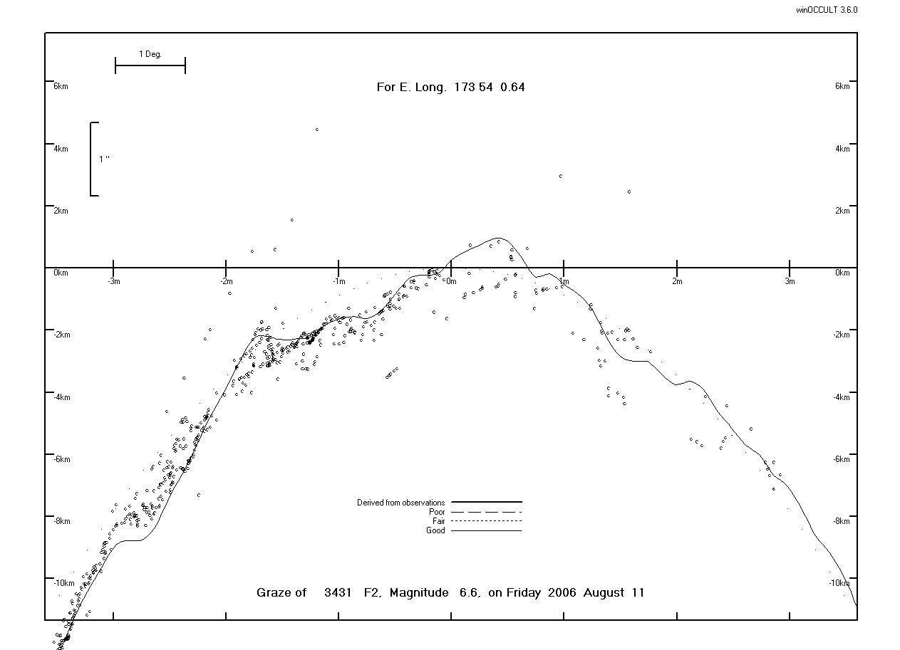
Grazing Occultation of ZC 3431 Magnitude 6.6 on 2006 August 11 U.T.
Nominal site altitude 0m

E. Longit. 	Latitude 	U.T. 	  Sun 	Moon 		TanZ 	PA 	WA 	CA
  o '  "          o  '  " 	h  m  s   Alt 	Alt Az 		o 	o 	o
170 0 00	-45 38 41 	15 6 38 	48 350 		0.90 	320.9 	342.66 	15.92N
170 7 30 	-45 32 22 	15 6 56 	48 350 		0.90 	320.9 	342.63 	15.95N
170 15 0 	-45 26 2 	15 7 14 	48 350 		0.90 	320.8 	342.61 	15.97N
170 22 30 	-45 19 40 	15 7 32 	48 349 		0.89 	320.8 	342.58	16.00N
170 30 0 	-45 13 16 	15 7 49 	48 349 		0.89 	320.8 	342.56 	16.02N
170 37 30 	-45 6 52 	15 8 7 		48 349 		0.89 	320.8 	342.53 	16.05N
170 45 0 	-45 0 25 	15 8 25 	48 348 		0.89 	320.7 	342.51 	16.07N
170 52 30 	-44 53 58 	15 8 44 	48 348 		0.89 	320.7 	342.49 	16.10N
171 0 00	-44 47 29 	15 9 2 		49 348 		0.88 	320.7 	342.46 	16.12N
171 7 30 	-44 40 58 	15 9 20 	49 347 		0.88 	320.7 	342.44 	16.14N
171 15 0 	-44 34 27 	15 9 38 	49 347 		0.88 	320.6 	342.41 	16.17N
171 22 30 	-44 27 53 	15 9 57 	49 347 		0.88 	320.6 	342.39 	16.19N
171 30 00	-44 21 19 	15 10 15 	49 346 		0.87 	320.6 	342.37 	16.22N
171 37 30 	-44 14 43 	15 10 34 	49 346 		0.87 	320.6 	342.34 	16.24N
171 45 0 	-44 8 5 	15 10 53	49 346 		0.87 	320.5 	342.32 	16.26N
171 52 30 	-44 1 27 	15 11 11 	49 345 		0.87 	320.5 	342.29 	16.29N
172 0 00	-43 54 47 	15 11 30 	49 345 		0.86 	320.5 	342.27 	16.31N
172 7 30 	-43 48 5 	15 11 49 	49 345 		0.86 	320.5 	342.25 	16.33N
172 15 0 	-43 41 22 	15 12 8 	49 344 		0.86 	320.5 	342.23 	16.35N
172 22 30 	-43 34 38 	15 12 27 	49 344 		0.86 	320.4 	342.20 	16.38N
172 30 0 	-43 27 53 	15 12 46 	49 344 		0.86 	320.4 	342.18 	16.40N
172 37 30 	-43 21 6 	15 13 5 	49 343 		0.85 	320.4 	342.16 	16.42N
172 45 0 	-43 14 18 	15 13 25 	50 343 		0.85 	320.4 	342.14 	16.44N
172 52 30 	-43 7 28 	15 13 44 	50 343 		0.85 	320.3 	342.12 	16.46N
173 0 00 	-43 0 38 	15 14 3 	50 342 		0.85 	320.3 	342.08 	16.50N
173 7 30 	-42 53 45 	15 14 23 	50 342 		0.85 	320.3 	342.06 	16.52N
173 15 0 	-42 46 52 	15 14 42 	50 342 		0.84 	320.3 	342.04 	16.54N
173 22 30 	-42 39 57 	15 15 2 	50 341 		0.84 	320.2 	342.02 	16.56N
173 30 0 	-42 33 2 	15 15 22 	50 341 		0.84 	320.2 	342.00 	16.58N
173 37 30 	-42 26 4 	15 15 42 	50 341 		0.84 	320.2 	341.98 	16.60N
173 45 0 	-42 19 6 	15 16 1 	50 340 		0.84 	320.2 	341.96 	16.62N
173 52 30 	-42 12 6 	15 16 21 	50 340 		0.84 	320.2 	341.94 	16.64N
174 0 00 	-42 5 5 	15 16 41 	50 339 		0.83 	320.1 	341.91 	16.66N
174 7 30 	-41 58 3 	15 17 1 	50 339 		0.83 	320.1 	341.89 	16.68N
174 15 0 	-41 51 0 	15 17 22 	50 339 		0.83 	320.1 	341.87 	16.70N
174 22 30 	-41 43 56 	15 17 42 	50 338 		0.83 	320.1 	341.85 	16.72N
174 30 0 	-41 36 50 	15 18 2 	50 338 		0.83 	320.1 	341.84 	16.74N
174 37 30 	-41 29 43 	15 18 22 	50 338 		0.83 	320.0 	341.82 	16.76N
174 45 0 	-41 22 35 	15 18 43 	50 337 		0.83 	320.0 	341.80 	16.78N
174 52 30 	-41 15 26 	15 19 3		51 337 		0.82 	320.0 	341.78 	16.80N
175 0 00 	-41 8 16 	15 19 24 	51 337 		0.82 	320.0 	341.76 	16.82N
175 7 30 	-41 1 4 	15 19 44	51 336 		0.82 	320.0 	341.74 	16.84N
175 15 0 	-40 53 52 	15 20 5 	51 336 		0.82 	320.0 	341.72 	16.85N
175 22 30 	-40 46 38 	15 20 26 	51 335 		0.82 	319.9 	341.71 	16.87N
175 30 0 	-40 39 24 	15 20 47 	51 335 		0.82 	319.9 	341.69 	16.89N
175 37 30 	-40 32 8 	15 21 8 	51 335 		0.82	319.9 	341.67 	16.91N
175 45 0 	-40 24 51 	15 21 28 	51 334 		0.81 	319.9	341.66 	16.92N
175 52 30 	-40 17 33 	15 21 49 	51 334 		0.81 	319.9 	341.64 	16.94N
176 0 00 	-40 10 15 	15 22 10 	51 333 		0.81 	319.8 	341.62 	16.96N
176 7 30 	-40 2 55 	15 22 32 	51 333 		0.81 	319.8 	341.61 	16.97N
176 15 0 	-39 55 34 	15 22 53 	51 333 		0.81 	319.8 	341.59 	16.99N
176 22 30 	-39 48 12 	15 23 14 	51 332 		0.81 	319.8 	341.57 	17.00N
176 30 0 	-39 40 50 	15 23 35 	51 332 		0.81 	319.8 	341.56 	17.02N
176 37 30 	-39 33 26 	15 23 57 	51 332 		0.81 	319.8 	341.54 	17.03N
176 45 0 	-39 26 2 	15 24 18 	51 331 		0.81 	319.8 	341.53 	17.05N
176 52 30 	-39 18 37 	15 24 39 	51 331 		0.81 	319.7 	341.52 	17.06N
177 0 00 	-39 11 10 	15 25 1 	51 330 		0.81 	319.7 	341.50 	17.08N
177 7 30 	-39 3 43 	15 25 22 	51 330 		0.80 	319.7 	341.49 	17.09N
177 15 0 	-38 56 16 	15 25 44 	51 330 		0.80 	319.7 	341.47	17.10N
177 22 30 	-38 48 47 	15 26 6 	51 329 		0.80 	319.7 	341.46 	17.12N
177 30 0 	-38 41 17 	15 26 27 	51 329 		0.80 	319.7 	341.45 	17.13N
177 37 30 	-38 33 47 	15 26 49 	51 328 		0.80 	319.7 	341.44 	17.14N
177 45 0 	-38 26 16 	15 27 11 	51 328 		0.80 	319.7 	341.42 	17.15N
177 52 30 	-38 18 45 	15 27 33 	51 328 		0.80 	319.6 	341.41 	17.17N
178 0 00 	-38 11 12 	15 27 54 	51 327 		0.80 	319.6 	341.40 	17.18N

Path coordinates are referred to WGS84 (as used by GPS).

Librations Long +1.47 Lat +0.14
P +341.4 D -0.3
Illumination of moon 93%-
Elongation of Moon 149
Vertical Profile Scale 2.37 km/arcsec at mean distance of moon
Horizontal Scale Factor 1.6 deg/min

Limiting Magnitudes for various telescope apertures (in mm)
CA\Tdia 50 100 150 200 250 300 350
  13.2 5.0 6.5 7.2 7.7 8.1 8.3 8.5
  15.2 5.4 6.9 7.6 8.1 8.5 8.7 8.9
  17.2 5.5 6.9 7.7 8.2 8.6 8.8 9.0
  19.2 5.5 6.9 7.7 8.2 8.6 8.8 9.0
  21.2 5.5 6.9 7.7 8.2 8.6 8.8 9.0
To participate in this graze please contact Haritina Mogosanu as soon as possible.